Magicians of the Gods
By Graham Hancock
Chapter 17
Mountain
It’s October 2013 and I’m on the slopes above the city of Cuzco, in the high Andes of Peru exploring
the incredible megalithic site of Sacsayhuaman with Jesus Gamarra, a descendant of the Incas.
Gamarra is in his mid-seventies, more than ten years older than me, but you’d never guess it from looking at him. He’s as nimble as a mountain goat, fully acclimatized to the altitude of 3,701 meters
(12,142 feet), and fit as an Olympic athlete after years of clambering around the passes and trails of
his homeland during a lifetime of research into the origins of Inca culture.
My first visit to Sacsayhuaman was in 1992, and I’ve been back many times since, always learning
something new. In Fingerprints of the Gods, published in 1995, I expressed my skepticism of the
orthodox theory that practically all of the great monuments of the Andes are the work of the Incas—whose empire was not much more than a century old at the start of the Spanish conquest of Peru in
1531. “Since it was known that the Incas made extensive use of Sacsayhuaman,” I wrote in
Fingerprints, “I could easily understand why it had been assumed that they had built it. But there was
no obvious or necessary connection between these two propositions. The Incas could just as well
have found the structures already in place and moved into them.”
1
In Heaven’s Mirror (1998) I further
developed the argument that the gigantic megalithic and rock-hewn constructions of the Andes, which
are by no means confined to Sacsayhuaman but are found all over the region, were not the work of the
Incas but of a much earlier, predecessor civilization long lost to history:
In such an event it is not necessary to imagine a complete break in continuity between the
hypothesized “elder culture” and the Incas; on the contrary, the latter could have inherited some
of the traditions and knowledge of the former and attempted, on a smaller scale, to mimic their
cyclopean world.
2
I didn’t know Gamarra or his work when I wrote the passages quoted above. Now, as he shows me
around Sacsayhuaman, carefully and painstakingly explaining everything he wants me to see, taking
me to hidden nooks and corners of the site that I was completely unaware of before, he opens my eyes
to all sorts of details that support and reinforce my earlier intuitions. More than that, he presents a
solid archaeological case, originally worked out by his father, Alfredo Gamarra, and greatly refined
and extended by himself, that would, I feel, be worthy of serious consideration by mainstream scholars—if, that is, the mainstream were not so locked in to the rigid preconception that all these
monuments are just a few hundred years old and entirely the work of the Incas.
3
It is notoriously difficult to know, with any useful level of certainty, the age of anonymous,
uninscribed stone monuments. Carbon dating of associated organic materials is only useful when we
can be absolutely certain that the materials being dated were deposited at the same time as the cutting
and placing of the stone we are interested in. In the case of many megalithic structures this is
impossible. Surface luminescence dating, which we saw in Chapter Ten has already produced some
anomalous results at the Pyramid of Menkaure and at the Sphinx and Valley Temples of Giza, has not
yet been widely taken up by the archaeological establishment and has never been applied to the
monuments of the Andes. In the absence of useful objective tests, therefore, the next routine strategy is
to look at architectural style and methods. Just as different styles of pottery can often provide reliable
indications as to what culture in what period made a particular piece, so too with architecture. The
rule of thumb is that very different styles and approaches to the construction or creation of stone
monuments, even if they stand side by side, are indicative of the involvement of different cultures
working at different periods in the past.
Unfortunately this logical and reasonable technique of stylistic dating is not popular with
archaeologists studying the monuments of the Andes—perhaps because, if they were to deploy it here,
as they do elsewhere, they would be forced to question the established theory that the Incas made
everything. Archaeology is a deeply conservative discipline and I have found that archaeologists, no
matter where they are working, have a horror of questioning anything their predecessors and peers
have already announced to be true. They run a very real risk of jeopardizing their careers if they do.
In consequence they focus—perhaps to a large extent subconsciously—on evidence and arguments
that don’t upset the applecart. There might be room for some tinkering around the edges, some
refinement of orthodox ideas, but God forbid that anything should be discovered that might seriously
undermine the established paradigm.
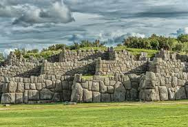
What Gamarra is showing me as we walk around Sacsayhuaman is that there are three distinctly
different styles of architecture here—so different, indeed, that it is extremely difficult to understand
why archaeologists insist they are all the work of the same Inca culture, and were all made during the
century or so prior to the arrival of the Spanish. It is unnecessary to repeat the detailed descriptions
of this site that I have given in my earlier books. In brief, however, Sacsayhuaman stands on a hillside
above and overlooking the city of Cuzco and consists of a series of three parallel rows of walls, all
about 6 meters (20 feet) high, constructed entirely of gigantic megaliths, some weighing in excess of
360 tons,
4 each wall offering a jagged, almost zig-zag profile, built into the side of a slope and
arranged in step fashion one above the other. Past the uppermost wall the slope continues to rise
toward the south and is littered with the ruins of a number of much smaller buildings; one of these,
right at the top, consisting of three concentric circles of nicely-cut blocks, preserved at foundation
level only, must have been impressive when it was intact. Beyond it, a valley overgrown with trees
and dense bushes slopes steeply down to the south with Cuzco nestling in its floor.
Turning northward, a grassy plateau perhaps 100 meters wide extends from the base of the lowest
of the three megalithic walls along its full length of some 400 meters. On the north side of the plateau,
a natural rocky knoll of volcanic diorite rises, but it has been cut and shaped into intricate terrace and
step formations. This is where Gamarra and I are now standing and he launches into an explanation.
“This is ‘Hanan Pacha’ work,” he says, indicating the beautifully cut diorite terraces at our feet.
“The first world. It was made thousands of years before the time of the Incas. They knew how to
shape stone then.” A mischievous grin. “They could do anything they wanted with it. Maybe it was
easy for them.” He stoops, beckons for me to look closely at the surface of the rock. “You see?”
I shrug. I’m puzzled. I’m not sure what he wants me to see.
“No tool marks,” he says. He gestures proudly at the whole carved, sculpted artifact, the whole
gigantic work of art that the knoll has been transformed into. “No tool marks anywhere.”
“So what did they do? Buff the tool marks off after they’d cut the stone?”
“No,” says Gamarra. “They didn’t need tools. They had another way. It was the same in the second
world, too, which I call ‘Uran Pacha.’” He points to the looming megalithic walls opposite. There is
some disagreement among the experts about exactly what kind of stone they are made from and where
it was quarried. The consensus, although some green diorite porphyry and some andesite are also
present, is that a very hard and dense form of local limestone was used for the megaliths themselves.
Quarries at 15 kilometers distance and at 3 kilometers distance have been identified as sources for
the limestone.
5

We scramble down the side of the knoll and across the grassy plaza until we stand beneath the
courses of hulking megaliths that have become the definitive image that Sacsayhuaman now projects
to the world. As always when I’m here, my first sensation is of wonder. I feel small, diminished, pintsized. It’s not just that the walls, and the blocks they’re built of, are big. They seem to have—dare I
say it?—a personality of their own, and it is the personality of a slumbering giant.
What’s spectacular about these walls, quite apart from their size, quite apart from the fact that
there are at least a thousand individual blocks, is the breathtaking virtuoso feat that has been
performed in joining them together. I mean, let’s be serious here. When you are building a wall in
which the smallest block you plan to use weighs a ton, while the majority weigh over 20 tons, where
many weigh 100 tons, some weigh 200 tons and a few weigh more than 300 tons, you have already set
yourself a formidable logistical challenge.
But then suppose, just for the hell of it, you decide to up the ante a little more and insist that these
walls must be constructed in the form of huge three-dimensional jigsaw puzzles. Every block has to
be a polygon with anywhere between six and a dozen sides, every polygon has to be different—no
two alike—and they must all fit together with one another so tightly that you won’t be able to get a
razor blade between the joints.
I can’t speak for the back of the blocks where they lock into other blocks behind them—again,
presumably, multi-dimensionally—but the patterns made along their weird cyclopean façades are
already complicated enough without considering what’s going on out of sight. It’s obvious, gazing up
in stupefied awe at the scale and complexity of the project, that this must have been an incredibly
difficult thing to do! Whoever was responsible for Sacsayhuaman’s megalithic phase can only have
been top-class professionals with years of experience behind them and a very long tradition of
distilled knowledge to draw upon. You can’t conceive, and plan, and build something like this with
only a century or two of trial and error behind you—as is supposed to be the case with the Incas.
These megaliths of Sacsayhuaman are the mature work of grandmasters of stone.
Moreover, throughout the Andes, there is no evidence of apprentices learning how to do this, no
early prototypes that are good but don’t quite succeed. Other structures might not be on the scale of
Sacsayhuaman (though many come close) but all of them, whether at Pisac, or Ollantaytambo or
Machu Picchu, or at a score of other sites, share the same level of complexity while embracing
different challenges—such as extremely difficult locations very far from the quarries—that
Sacsayhuaman does not have to overcome. All of them are masterworks from the beginning. All of
them are perfect. It’s almost as if, as Gamarra says, “it was easy for them.”
I know he has a theory to explain this. The theory is that gravity was lower during his first two
“worlds”—the Hanan Pacha stage and the Uran Pacha stage—and that this made stone lighter and
easier to manipulate. The lowered gravity is linked in his mind with the notion that the earth once
made much closer orbits around the sun—an orbit of 225 days and an orbit of 260 days—before
settling in to its present 365 day path.
6 He could be right; new science suggests that the orbits of the
planets are not fixed and stable but can be subject to radical changes that, among other things, are
capable of increasing the flux of comets into the inner solar system.
7
However, this isn’t the part of his theory I’m interested in. Where I feel he is solidly persuasive is
in his observations of the anomalous character of the monuments of the Andes—observations that are
based on fifty years of his own fieldwork and sixty years of fieldwork by his father. The Gamarras
have walked the walk and earned the right to speak out on this matter, and when they speak, though
they themselves are of Inca descent, their message is absolutely clear—many of the great architectural
works that are attributed to the Incas were not made by the Incas. There are traces of a lost
civilization here. Indeed not just one lost civilization, but—if Gamarra’s time-frame is correct—two.
“All the big blocks of Sacsayhuaman are from the Uran Pacha period,” he says. We’re standing in
a corner at a junction of a dozen or so of these incredible blocks. Gamarra highlights again the
precision of their joints that look as though some modern machine tool has been at work, and the
daunting complexity of the patterns they form. Then he draws my attention to something else. Several
of the blocks have weird circular hollows and shallow tracks with raised edges scalloped into their
faces along with other peculiar, seemingly random, patterns. “No tool marks,” he reiterates. “No
chisels. No hammers.”
“So how did they do it?”
“Doesn’t it look,” Gamarra asks, “like they worked with the stone when it was soft?” He runs his
hand along the curves and angles of a polygonal joint. “Like butter? So they could mold everything
together?”
Suddenly all becomes clear. The strange shapes I’m seeing in the rock would be easy, indeed
effortless, to create if these blocks were made of something of the consistency of room-temperature
butter instead of cold, hard limestone. Then as well as molding them together to create this massive
jigsaw puzzle effect, the tip of a table-knife could be used to gouge out the shallow scallops and the
back of a spoon would serve to make the hollows.
It’s an attractive idea and I don’t have to buy into Gamarra’s theories about orbits and gravity in
order to explore it further. There are other ways of explaining the patterns. For example, the
technology of a lost civilization might have been up to the challenge of softening rock so that it could
be worked like butter. Perhaps heat was involved? An intriguing study by the Institute of Tectonics
and Geophysics of the Russian Academy of Sciences, working in cooperation with Peru’s Ministry of
Culture, produced evidence that the limestone of the Sacsayhuaman megaliths was at some point
subjected to temperatures in excess of 900 degrees centigrade and possibly as high as 1100 degrees
centigrade.
When the Russian researchers went to the quarries where the blocks are believed to have been cut,
they found the natural limestone filled with tiny organic fossils. This is what you would expect, since
limestone is a sedimentary rock that forms under ancient seas and consists largely of the remains of
tiny shells and the micro-skeletons of other marine organisms. Strangely, when samples from the
Sacsayhuaman megaliths were assayed by the researchers they confirmed that the rock was indeed
limestone of “high density.”
8 However there were:
no obvious fossils and organic remains in it, but only clearly visible fine-grained structure.
9
Their conclusion was that the blocks had been subjected to intense heat between the time when they
were quarried and the time when they were placed into the wall and that this heat was sufficient to
reduce the fossils to indeterminate fine-grained structure:
Of course we need more detailed researches and analysis in order to estimate the real reason
for the thermal effects on the studied limestone … But the fact remains the fact—
recrystallization of biogenic siliceous limestone into microcrystalline siliceous limestone. The
result of this process we can see in the material forming the wall polygonal blocks of
Sacsayhuaman. In normal nature conditions this process is absolutely impossible.
10
“Some magic presided over its construction…”
Jesus Gamarra and I continue our exploration by climbing the stairways through the lines of the
megalithic walls until we reach the slope above and can approach the dilapidated ruins littering the
hilltop. “These,” says Gamarra, indicating the ruins, “are examples of what was done in the Ukun
Pacha period—the work of the Incas.” Some of it, he makes clear, for example the structure of three
concentric circles of walls, was very nicely done. The Incas called it Muyuc Marca, he tells me. It
was a tower that once rose to over 30 meters in height and was built as an imperial residence for the
Emperor—whose title was “the Inca.” Only later, and by extension, did the entire nation become “the
Incas.”
Gamarra’s argument is that in buildings like Muyuc Marca we are looking at the finest results the
Incas were capable of. Yet these results are so patently inferior to the megaliths—and so different—that they must obviously be accepted as the work of another culture.
Curiously, although such ideas are regarded as heresy by archaeologists today, this was not the
case when the Andes first came under serious scientific scrutiny in the late nineteenth and early
twentieth centuries. For example, the great geographer Sir Clements Markham, who traveled
extensively in Peru and wrote the classic study The Incas of Peru, states that “the Incas knew
nothing” of the origins of Sacsayhuaman:
Garcilaso refers to towers, walls, and gates built by the Incas, and even gives the names of the
architects; but these were later defenses built within the great cyclopean fortress. The outer
lines must be attributed to the megalithic age. There is nothing of the kind which can be
compared to them in any other part of the world.
11
The “Garcilaso” mentioned by Markham is the chronicler Garcilaso Inca de la Vega, the son of a
Spanish conquistador and an Inca princess, a heritage that gave him unique access to genuine Inca
traditions, particularly since he was born and brought up in Cuzco and spoke Quechua, the language
of the Incas, as his mother tongue. Had the megalithic elements of Sacsayhuaman been recent work,
done in the century before Garcilaso’s birth, there should have been fresh and clear memories, even
eye-witness accounts, of so magnificent an achievement. But Garcilaso reports nothing of the sort and
instead can only offer magic as an explanation for what he describes as “an even greater enigma than
the seven wonders of the world.” Here is what he wrote about Sacsayhuaman in his Royal
Commentaries:
Its proportions are inconceivable when one has not actually seen it; and when one has looked at
it closely and examined it attentively, they appear to be so extraordinary that it seems as though
some magic had presided over its construction; that it must be the work of demons, instead of
human beings … If we think, too, that this incredible work was accomplished without the help
of a single machine, is it too much to say that it represents an even greater enigma than the seven
wonders of the world? How can we explain the fact that these Peruvian Indians were able to
split, carve, lift, carry, hoist and lower such enormous blocks of stone, which are more like
pieces of a mountain than building stones, and that they accomplished this, as I said before,
without the help of a single machine or instrument? An enigma such as this one cannot be easily
solved without the help of magic.
12
Are we looking, yet again, at the handiwork of the Magicians of the Gods? Remembering that the
great temple of Edfu in Upper Egypt was dedicated to the god Horus, who was sometimes depicted as
a falcon and sometimes as a lion, it is intriguing to discover that the very name “Sacsayhuaman”
means Falcon (specifically “Satisfied Falcon”). Furthermore, it has long been recognized that
Sacsayhuaman forms part of a large geoglyph, once visible from surrounding mountain peaks, in
which it combines with the oldest quarters of Cuzco to form the shape of an immense feline—a puma,
the closest creature in the Americas to an old world lion. The river Tullumayo (now diverted
underground where it passes through the city) used to serve as the spine of this ancient lion. The torso
was the spit of land between the Tullamayo to the east and the river Huatnay (now also underground)
to the west. Sacsayhuaman is still recognizable as the head of the lion. The zig-zag walls, that Jesus
Gamarra attributes to the second (Uran Pacha) episode of civilization in the Andes, outline the upper
side of its snout and muzzle, with the snout facing due west, the direction of the equinox sunset, just as
the Great Sphinx of Giza faces due east, the direction of the equinox sunrise.
13
There are traditions, supported by some modern excavations, of a network of tunnels under the
Sphinx where mysterious treasures lie concealed.
14 There are virtually identical traditions—again
supported by recent excavations—of a labyrinth of enormously long tunnels under the head of the
Sacsayhuaman lion “into which people descend to be lost forever, or to emerge, gibbering, mad,
clutching items of treasure.”
15
Before we leave Sacsayhuaman, Jesus Gamarra takes me to a very strange place a few hundred
meters to the northeast of the megalithic walls, where a narrow stairway with a dozen steps appears
to have been molded—not cut—into the midst of a massive boulder 20 feet high and as many wide.
The stairway would only have been visible from above when it was made, but the boulder has been
split into two parts—by an earthquake, Gamarra thinks—with one side standing upright and the other
leaning away from it at an angle of about 40 degrees, thus exposing the steps which we approach from ground level. At the point where the lowest of the steps would originally have touched the earth,
Gamarra shows me the entrance to what looks like a deep, dark hole, now filled up with slabs of
rock. “It’s a tunnel,” he tells me. “It goes under the ground all the way to Cuzco, but the government
blocked the entrance to stop people exploring it.”
Civilizing mission
Over the next few days Jesus Gamarra shows me more of the evidence behind his theory. Indeed now
that I’ve understood his reasoning, I can see examples everywhere.
In downtown Cuzco—the name of the city means “the navel of the earth” in the Quechua language
of the Incas
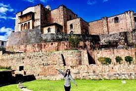
16—he takes me to the ancient temple known as the Coricancha, which was converted into
a cathedral after the Spanish conquest. The temple was used by the Incas, indeed it was central to
their sacred life, but Gamarra does not believe that the Incas built it. In his view, though they
undertook some repairs and added some minor constructions of their own, the bulk of the polished,
precise, sharply angled gray granite stonework is from the Uran Pacha (“second world”) period and
thus predates the Incas by thousands of years. He’s reluctant to commit to a timescale, but suggests
that the Coricancha was originally raised up “more than 20,000 years ago” in order to venerate an
even earlier Hanan Pacha (“first world”) monolithic site—the original “uncovered navel stone”
from which the city derives its name.
17
The Incas preserved a tradition, passed down to us by Garcilaso Inca de la Vega, concerning the
foundation of Cuzco. It seems that some sort of cataclysm had affected the world, some sort of
disaster, and the inhabitants of the Andes had fallen into a very lowly state. Garcilaso was told by his
own uncle, an Inca nobleman, that the people of that far-off time “lived like wild beasts, with neither
order nor religion, neither villages nor houses, neither fields nor clothing … They lived in grottoes
and caves and, like wild game, fed upon grass and roots, wild fruits, and even human flesh … Seeing
the condition they were in, our father the Sun was ashamed for them, and he decided to send one of
his sons and one of his daughters from heaven to earth” to bring them the gifts of civilization and to
teach them “to obey his laws and precepts … to build houses and assemble together in villages.”
18
This royal couple—for, like Isis and Osiris in Egypt they were brother and sister as well as
husband and wife—traveled the land carrying a golden rod given to them by the Sun God, who
instructed them to plunge it into the earth at various points until they found a place where it would
disappear at one thrust and there they were to establish their court. Finally, “the Inca and his bride
entered into Cuzco valley. There [at a spot called Cuzco Cara Urumi, the Uncovered Navel Stone]
they tried their rod and not only did it sink into the earth, but it disappeared entirely … Thus our
imperial city came into existence.”
19
There is an exact parallel here to the story of the Zoroastrian patriarch Yima, recounted in Chapter
Seven, who was given a golden poniard by a god and who likewise plunged it into the earth as the
founding act of a civilization.
And what a civilization it was that flowered in the Andes! Certainly the extraordinary
accomplishment of the giant edifices of the Coricancha seems to suggest the application of more than
ordinary skills and abilities. The huge granite blocks are so finely cut—Gamarra insists they were
molded into shape—that the towering inner chambers look more like the parts of some gigantic,
sophisticated machine than of a temple. Adding to this impression are the complicated series of
grooves, channels, holes and niches indented into several of the blocks, giving them the appearance of
printed circuit boards from which the circuitry has been removed, leaving only empty tracks.
After spending some hours inside the Coricancha, Gamarra takes me outside into the neighboring
Loreto Street which he promises will provide a particularly graphic demonstration of his arguments.
It’s a narrow alley bounded by high walls and in these walls, surmounted by sections of modern
plasterwork, four distinctly different styles of stone masonry are visible. Of these, Gamarra says, two
are Inca, Ukun Pacha, one is from the colonial period around the seventeenth or eighteenth century,
and one dates back to the Uran Pacha period.
Along a large part of one side of the street there are granite blocks that are every bit as fine and
beautifully fitted as those inside the Coricancha. Indeed, this section of the wall is the exterior
elevation of one of the Coricancha’s large chambers, and therefore, according to Gamarra, is from the
Uran Pacha period. The joints between the blocks are so thin, and yet so complex, with interlocking
elements, that they do indeed seem molded together. In addition—and he has previously shown me
examples of this at Sacsayhuaman as well—there is a curious glassy sheen around the joints, which
he believes is evidence of “vitrification caused by exposure to intense heat.” He makes a convincing
case that what we’re looking at is different from the normal shine that passers-by might impart to the
stone by rubbing and touching it over the centuries. Indeed the “vitrified” elements—and I make no
claim that this is what they are—form a clear skin over the underlying blocks that is particularly
evident where areas have been damaged or broken.
Beside the courses of Uran Pacha blocks, though not rising to the same height, are others that look
superficially similar but that, on closer examination, prove to be much more crudely made with
obvious tool marks, no glassy sheen and yawning gaps between some of the joints. “Good Ukun
Pacha work,” comments Gamarra. “Made by the Incas. They were doing their best to imitate the
Uran Pacha style, but they couldn’t quite succeed and their efforts got poorer and poorer.”
He indicates four courses of irregular cobbles higher up with wide spaces between the joints
filled by adobe. “Colonial period,” he says.
Finally he takes me to the other side of the street to show me a long section of dry-stone wall. The
cobbles have been subjected to a certain amount of shaping, but are clumsily and unevenly fitted
together. There’s no adobe in the gaping joints. “Made by the Incas,” says Gamarra.
“And what’s the opinion of the archaeologists?” I ask.
A grin. “They recognize the colonial work, but they’ve fooled themselves into believing that
everything else was done by the Incas. They are so convinced there was no earlier, more advanced
civilization here, that they’re blind to the huge differences between the Uran Pacha blocks and the
Inca workmanship.”
“I suppose the fact that the Incas themselves sometimes attempted to imitate the Uran Pacha style
—at least in that section over there—makes things more complicated?”
“More complicated, yes. But still they should be able to see. Such profound changes in the quality
of workmanship, especially when examples like this are found all over the region, should give the
hint that different cultures were involved.”
Sacred valley
If the focus around the Coricancha is the fine megalithic work that Gamarra associates with the Uran
Pacha period, there are many other structures in the area that he sees as pure Hanan Pacha—the
oldest phase of Andean civilization, where the work in stone is entirely monolithic. Several great
outcrops of bedrock have been completely refashioned into bizarre complexes of steps, terraces and
alcoves. At Qenko, one such outcrop a little way beyond Sacsayhuaman, there are multiple snake-like
grooves and channels winding their way down the sides of a mystic dome filled with caves, ledges,
passageways and hidden niches. On the very top, again carved—or molded—from the raw stone, is
an oval protrusion surmounted by a stubby double prong. There are also the outlines of various
animals—a puma, a condor, a llama—and yet more terraces and steps leading nowhere.
We go on to another sculpted outcrop a hundred meters tall known locally as the Temple of the
Moon. At the base of the mound there’s a dark, mysterious, folded slit that leads within, along the
edge of which, at about shoulder height, emerges the sinuous sculpted form of a serpent with a strange
bulbous head. To the right of the entrance the rock takes distinctive shape as the head of an elephant,
complete with trunk, eyes and ears. About the serpent there’s no doubt, but is the elephant an example
of what psychologists call pareidolia—the human tendency to see meaningful shapes and patterns that
don’t really exist? Or did some cunning artist in ancient times deliberately set out to sculpt the
appearance of an elephant emerging from the rock? If the latter, then we have a problem with history,
since the last species related to elephants that could be portrayed here—Cuvieronius—became
extinct in South America at least six thousand years ago, while the Incas who are supposed to have
made the Temple of the Moon date back less than a thousand years.
I’ll have more to say about the serpent, and the “elephant,” later. Meanwhile, as I stoop down
through the slit in the rock to enter the temple I notice another carved stone animal—a puma, this time,
and somewhat damaged—at my feet.
Now I’m inside what feels like the womb of the mountain, and a soft velvety gloom envelops me.
The cave is five meters wide with an organic, meandering feel to it, but to my left a couple of deep
alcoves have been cut into the wall, while twenty meters ahead a shaft of brilliant, golden light finds
its way in through some aperture in the rocky mound above and illuminates a stone plinth about a
meter and a half high with two large steps. I climb up onto the plinth and sit there, my back resting
against the living rock, deep in thought.
Gamarra says this place is from the most ancient Hanan Pacha epoch, that it has nothing to do
with the Incas, and that it long predates the Uran Pacha period that was responsible for the megaliths
of Sacsayhuaman and the stunning, high-precision architecture of the Coricancha. Looking around,
taking in the atmosphere, I’m more and more inclined to agree with him. The people who made this
cave temple were not the same as those who made the Coricancha. It’s not just different building
styles that are involved in each of the different periods. It’s a different ethic and a different spiritual
heartbeat.
From the Temple of the Moon we go straight on to Pisac, a drive of eighteen kilometers along the
edge of the Sacred Valley of the Vilcanota River. Its waters sparkle far below us, while all around the
spectacular mountain country glows emerald, thanks to countless fertile terraces that the Incas
undoubtedly did create and that provided their empire with vast agricultural wealth. The sheer
magnitude of the task of organizing and building the thousands upon thousands of neat dry-stone walls
that hem in these terraces—which are found in every viable spot throughout the length and breadth of
the Andes—almost beggars belief. It’s a comparable achievement to the architectural wonders. And
so too are many other aspects of Inca civilization—which I do not mean to diminish in any way with
the suggestion that there might have been earlier cultures. Quite the contrary, I suspect part of the
reason the Incas were so remarkable is that they were the inheritors of an incredible legacy of
wisdom and knowledge from the past.
So it’s in a setting of great natural beauty overlooking the Sacred Valley that we explore Pisac, a
site less famous, but in many ways more spectacular than Machu Picchu, which lies another seventy
kilometers to the northwest.
As at Machu Picchu, the centerpiece at Pisac, around which everything else seems focused, is an
Intihuatana (the word means “hitching post of the sun”)—a massive outcrop of rock, shaped by
human hands in what Gamarra calls the Hanan Pacha style, with a gnomon sticking up from its
summit. Surrounding it, and in some cases molded to its surface, are walls of beautifully shaped
polygonal blocks in the later Uran Pacha style, which seem to have been designed to cradle and
protect the Intihuatana. And around them are Ukun Pacha—Inca—structures of simpler, cruder
stonework.
“Each of these cultures,” Gamarra explains, “venerated and respected the culture that went before.
They expressed their feelings of respect by building over and around the work of their predecessors
and by attempting to copy what they did. As I showed you in Loreto Street, the Incas sought to emulate
the Uran Pacha style, but they didn’t have the knowledge or the right conditions to do such a good
job.”
By “the right conditions” Gamarra means the lowered gravity and greater malleability of stone that
he hypotheses in past epochs, but I don’t need to embrace that to accept that his observations about
the different building styles and their likely origination by different cultures make complete sense of
what we’re looking at.
I see many more examples of these three distinctive styles, sometimes with Gamarra to guide me,
sometimes not. Machu Picchu itself, which I’ve written about at length in previous books, is, of
course, the archetypal Hanan Pacha site adopted and overbuilt by later cultures. Then there’s a
mysterious little cave overlooking a remote valley, through the floor of which passes the rail track
connecting Cuzco to Machu Picchu.
20
It’s quite a clamber three hundred meters up the almost sheer
valley side and along a narrow track, but the end result is worth the effort. At the front of the cave
(see Plate 60) a black andesite boulder has been sculpted—or molded?—into a curious-looking
shrine with a step-pyramid motif engraved upon it.
Treasure hunters have been here and dynamited the shrine, but enough of it survived the explosion
to get a sense of how beautiful it must have been before it was attacked. In the same Hanan Pacha
style, one wall of the cave appears to have been planed smooth and an alcove with absolutely precise
straight edges, as though milled by a machine tool, has been cut into it. But on the other side, on my
right as I look out of the cave, an Inca wall of rough stone mortared together with adobe has been
built, and into this wall—crudely done—six alcoves have been fashioned in an obvious attempt to
mimic the high-precision rock-cut alcove on the left. The qualities and styles of workmanship are so
completely different that it makes no sense, as is presently the case, to insist that both the rock-cut
work and the crude wall were produced by the same culture. Gamarra’s theory that a much older
monument has been honored and mimicked by the Incas better fits the evidence before my eyes.
Déjà vu

Heading out of Peru on our way to Bolivia, we stop in the town of Puno on the shores of Lake
Titicaca, 3,812 meters (12,507 feet) above sea level and from there, the next day we drive 22
kilometers south to a dramatic mesa at an altitude of 4,023 meters (13,198 feet), on top of which is
perched the archaeological site of Cutimbo. The main features of the site—several tall towers, some
circular, some square, and known collectively as chullpas—are visible from the road. They are
thought to have been built as tombs for the nobility of a local Indian culture, the Lupakas, who were
made vassals of the Incas in the period between AD 1470 and AD 1532.
21 Undoubtedly there were
burials within the chullapas in that period,
22 but the possibility must be considered that these were
intrusive and that the towers, made from fine polygonal blocks that have all the hallmarks of Jesus
Gamarra’s Uran Pacha style, are much older than their latest use.
I’m getting accustomed to the thin air of the Andes by now, but it’s a long hike through yellow
pampas grass up the side of the mesa under a burning morning sun. Once we get to the top, however,
my fatigue vanishes when I start finding, and Santha starts photographing, really interesting imagery
carved in high relief on the sides of a number of the towers and on scattered blocks lying at random here and there, the result of more demolition efforts by treasure hunters.
It’s this imagery, on the far side of the world, including that stone serpent in the Temple of the
Moon, that a year later will suddenly come to mind in ŞanlIurfa Museum, as I study the collection of
reliefs from Göbekli Tepe. I leave readers to form their own views from Plates 61–72, but the
obvious parallels include the following:
At Göbeklitepe there is a creature, sculpted in high-relief, identified by Klaus Schmidt as a
beast of prey with splayed claws and powerful shoulders, its tail bent to its left over its body. A
very similar animal is seen at Cutimbo with the same splayed claws and the same powerful
shoulders, while the tail instead of being bent to its left is bent to its right.
At both Göbeklitepe and Cutimbo, reliefs of salamanders and of serpents are found. The
style of execution in all cases is very similar.
At about the level of the genitals of the so-called “Totem Pole” of Göbekli Tepe, a small
head and two arms protrude. The head has a determined look, with prominent brows. The long
fingers of the hands almost meet. The posture is that of a man leaning down through the stone
and playing a drum. This is also the posture of two figures at Cutimbo, who emerge from a
large convex block on one of the circular towers. They have the same determined features and
prominent brow ridges as the figure on the “Totem Pole.”
The two serpents on the side of the “Totem Pole” have peculiarly large heads, making them
look almost like sperm. So, too, does the serpent that emerges from the dark narrow entrance of
the Temple of the Moon above Cuzco.
Lions feature in the reliefs at Göbekli Tepe, pumas feature in the reliefs at Cutimbo and
again the manner of representation is similar.
I don’t know what to make of these similarities. Just coincidences? Very likely. Even so they go on.
City of Viracocha
It’s quite a trial crossing the land border from Peru into Bolivia through a series of bureaucratic
hurdles and long queues, but close by is the charmingly-named town of Copacabana and a
comfortable hotel overlooking Lake Titicaca. If we had more time we’d visit the Islands of the Sun
and Moon by boat from here; but we’ve been to them often before and they’re not our target on this
trip. It’s Tiahuanaco up on the Altiplano at 12,800 feet, near the southeastern shore of the giant lake,
that we’re keen to get back to.
Orthodox archaeologists date Tiahuanaco to the period between 1580 BC and AD 724, but in both
Fingerprints of the Gods and Heaven’s Mirror I argued that it might ultimately prove to be many
thousands of years older than that. Up to now less than two percent of the site has been excavated and
I think it likely that further excavations will force a change of the archaeological paradigm. It is
perhaps a sign of things to come that on 27 March 2015 Bolivia’s Tiahuanaco Archeological
Research Center reported that a survey with ground-penetrating radar had revealed the existence of a
complete “buried pyramid” in a previously un-excavated area of the site, together with “a number of
underground anomalies” that are thought to be monoliths. A five-year plan of excavation to learn more
about these mysterious structures has now been launched.
23

Since I’ve already described Tiahuanaco at length in my previous books, it seems superfluous to
repeat those descriptions here. What’s new for me on my October 2013 visit is a much closer look at
the machine-age precision of the megaliths littered around the immense platform of the Puma Punku,
and the truly intricate manner in which so much of the stone has been cut—molded, I think Jesus
Gamarra would say. As at the Coricancha, I come across several megaliths that resemble circuit
boards stripped of their circuits. There are others with cross-shaped indentations that look as though
they were part of some contraption—as though perhaps they were to receive the ends of metal axles,
or connecting pieces that have long since oxidized or been carried off by looters.
Particularly striking, because I’ve missed them before on all previous visits, are a couple of rows
of massive andesite blocks all identical, as though stamped out of some mold, and all shaped like the
letter “H.” The comparison with the “H” motif at Göbekli Tepe, on the belts of the pillars, for
example, is irresistible even if it is just another coincidence (see Plates 75 and 76).
Then there’s the pillar statue in the semi-subterranean temple at Tiahuanaco. Like the Totem Pole
of Göbekli Tepe, it is anthropomorphic. Like the Totem Pole at Göbekli Tepe, it has serpents writhing
up its side. Like the Totem Pole at Göbekli Tepe, the long fingers of its hands almost meet in front of
its body. The face is human not animal, however, and it’s heavily bearded. Nonetheless, the figure of
an animal is carved on the side of its head and this animal resembles no known species more closely
than it does Toxodon (see illustration above), a sort of New World rhino that went extinct during the
cataclysms at the end of the Ice Age around 12,000 years ago. This isn’t pareidolia—the figure is
definitely there. So there’s only one question—and it’s difficult to answer: is this a depiction of
Toxodon, or is it some creature of the artist’s imagination?
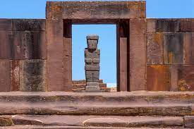
I move on into the Kalasasaya, the huge open rectangle, bounded by megalithic walls, that appears
to have been the central ceremonial area of ancient Tiahuanaco. On the monolithic Gateway of the Sun
is carved the image of another elephant with tusks and trunk, like the elephant sculpted into the living
bedrock of the Temple of the Moon near Sacsayhuaman. This Tiahuanaco “elephant” has been
dismissed by critics as merely the heads of two condors side by side, but if that is the case, then the
image on the matching—mirror—side of the Gateway is puzzling (see illustration below), since it
definitely shows two condors side by side yet is different from the elephant relief.
If it was modeled from nature it doesn’t have to be that old—Cuvieronius, as noted earlier,
survived in South America until 6,000 years ago. On the other hand, most related mastodon species
went extinct during the Younger Dryas between 12,800 and 11,600 years ago.
The Kalaysasaya is a huge, largely empty, open space. But there are two statues here that I want to
take another look at—the Ponce Monolith, named after Carlos Ponce Sanginés, the “godfather” of
Bolivian archaeology, and El Fraile (“the Friar”) a smaller, slightly different version done in the
same general style.
What’s striking about both of them are the hand positions, with the fingers almost meeting across
the belly—virtually identical to the hand positions on the Göbekli Tepi pillars or on the Totem Pole.
However, the Tiahuanaco figures, like the Mesopotamian Apkallus, carry objects in their hands—not
a cone and a bucket but, as archaeologist and ethnobotanist Constantino Manuel Torres has
demonstrated, snuff trays for the consumption of hallucinogenic DMT powders from the Amazon.
24
It’s a reminder, even up here in the cold, austere highlands of the Altiplano, that the Amazon with
its riotous, exuberant life is not far away. When we are looking for the remnants of a lost civilization
that once perhaps spanned the globe, it might not be the first place we would think of, but its dense
jungles hide so much and recent clearances have revealed the remains of ancient cities, megaliths,
gigantic earthworks and soils enriched by some mysterious process that keeps them fertile for
thousands of years.
25
What is also clear is that a legacy of high-level scientific skills, inherited from somewhere, was
passed down through generation after generation of shamans. The making of a psychedelic, DMT containing brew—Ayahuasca—from two jungle plants, neither of which is an orally active
psychedelic in its own right, is an astonishing pharmacological achievement when we remember that
there are 150,000 different species of plants and trees in the Amazon. Likewise a nerve poison like
Curare, which has eleven different ingredients and which produces lethal fumes during preparation, is
not something that can be dreamed up overnight, but requires the application of a thoroughly worked out science.
Another point of interest about the Tiahuanaco monoliths is that their garments from the waist
down are patterned in the form of fish scales. Here, too, is a parallel to the Apkallus—the bearded,
“fish-garbed figures” who brought high civilization to Mesopotamia and whose mysteries we
explored in earlier chapters. Nor is it as though bearded figures are missing from the repertoire of
Tiahuanaco. Two have survived, and one on the pillar in the semi-subterranean temple has been
identified since time immemorial with the great civilizing deity Kon-Tiki Viracocha, who I wrote
about at length in my previous books and who is described in multiple myths and traditions as being
white skinned and bearded. Garcilaso Inca de La Vega, who lived through the last years of the
conquest and grew up in Cuzco, wrote that Viracocha:
wore a thick beard—whereas the Indians are clean shaven—and his robe came down to the
ground, while that of the Incas came only to their knees; this is why the Peruvian people called
the Spanish “Viracochas” the minute they saw them … The Indians had no difficulty believing
that the Spaniards were all the sons of God …26
In other words, with their white skins and beards the Spanish fitted an ancient tribal memory, passed
down from generation to generation, of civilizing heroes who had come to the Andes in remote
prehistory and taught the people there the skills of agriculture, architecture and engineering.
And what about Kon-Tiki Viracocha himself? What happened to him?
It seems after a civilizing mission across the Americas:
His travels took him to Manta (Ecuador) from where he crossed the Pacific Ocean, walking on
the water.
27
I am not going to repeat here the stories and traditions of Viracocha that I reported in my previous
books, but he is the Osiris and the Quetzalcoatl of the Andes who comes in a time of darkness, after a
great flood, bringing the gifts of civilization.
That he should leave eventually, and that he should do so by some high-tech means, “walking on
the water” across the Pacific Ocean, is intriguing.
Let’s follow him and see where he might have gone …
18
Ocean
According to the most ancient traditions of Mesopotamia, humanity was created at the “navel of the
earth,” in uzu (flesh), sar (bond), ki (place, earth).
1
In the Rig Veda, the most ancient scripture of
India, the universe was born and developed “from a core, a central point.”
2 Bearing markings that
Jesus Gamarra would instantly nominate as belonging to the oldest, Hanan Pacha, style of the Andes,
the Shetiyah—Foundation Stone—of the Temple Mount in Jerusalem, now the “rock” of the Dome of
the Rock (see Chapter Twelve), is considered to be “the center of the earth.”
3
Indeed this notion that
there are certain primordial centers of creation from which all else grows is a global theme of ancient
religion and mythology:
The Most Holy One created the world like an embryo. As the embryo grows from the navel, so
God began to create the world by the navel and from there it spread out in all directions.
4
In the Greek myth of the universal Deluge, sent by Zeus to punish mankind for wickedness, the only
survivors are Deucalion and Pyrrha. Their Ark comes to rest on Mount Parnassus, high above Delphi,
a site regarded throughout classical antiquity as the “navel of the earth.”
5 Just as Heliopolis in Egypt
possessed the sacred Benben, a betyl stone fallen from heaven (see Chapter Eleven), so too Delphi
possessed a betyl, nominated as its omphalos, or “navel stone.” It was specifically identified in
Greek mythology as the stone which had been fed to the monstrous time-god Kronos—who devoured
his own children—in place of the infant Zeus. When Zeus grew to manhood, he took revenge on
Kronos, “driving him from the sky to the very depths of the universe” after first—in imagery that calls
to mind the debris stream of a comet—forcing him to vomit up the stone.
6 “It landed in the exact
center of the world, in the shrine at Delphi.”
7
We saw in the last chapter that the name of Cuzco, the megalithic city in the Peruvian Andes, means
“the navel of the earth.” More than 4,000 kilometers (2,500 miles) to the southwest, across the Pacific
Ocean, the ancient name of Easter Island, Te-Pito-O-Te-Henua, also means “the navel of the earth”
8
—which in turn has affinities to the ancient name of Tiahuanaco, Taypikala, “the stone at the center.”
9
Indeed, on the edge of Easter Island’s La Perouse Bay there is a mysterious spherical, carefully tooled stone called Te-Pito-Kura—the “golden navel stone”—which is regarded as the navel of the
island itself.
10
Traditions state that there was once a time when “great magicians” used this stone to focus their
mana power—literally “sorcery”—to make the Moai, the famous megalithic statues of the island
“walk” from the quarry to the places where they were to be set up.
11 An almost identical notion is
preserved among the indigenous Aymara of Bolivia, who have lived in the vicinity of Tiahuanaco
since time immemorial. They state that the mysterious city with its own extraordinary megalithic
statues was built by magic in a single night and that “the stones came down of their own accord, or at
the sound of a trumpet, from the mountain quarries and took up their proper positions at the site.”
12
Nor do the parallels stop there. Since the late 1940s, when Thor Heyerdahl undertook his KonTiki expedition (named after Kon-Tiki Viracocha, the civilizing deity of Tiahuanaco, whom we met at
the end of the last chapter), it has been noticed that there are similarities between the statues of
Tiahuanaco and the Moai of Easter Island. For example, as we’ve seen, the figures of Viracocha at
Tiahuanaco display prominent and pronounced beards (a sharp contrast to the indigenous inhabitants
of the Andes who are not able to grow strong beards) and there is no doubt that the prominent chins of
the Easter Island figures are also meant to represent beards (Plates 78 and 79). As Heyerdahl
commented:
The statues on Easter Island … had their chins carved pointed and projecting, because the
sculptors themselves grew beards.
13
The Norwegian adventurer was likewise struck by the way that the Easter Island figures and the
Tiahuanaco figures have “their hands laid in position on their stomachs.”
14 Both also wear distinctive
broad belts. “The sole decoration of the Easter Island figures,” he wrote:
is a belt which was always carved round the figure’s stomach. The same symbolic belt is to be
found on every single statue in Kon-Tiki’s ancient ruins by Lake Titicaca.
15
Heyerdahl, who I had the privilege to know and who was a strong supporter of the lost civilization
hypothesis,
16 did not have the opportunity to visit Göbekli Tepe before he passed away in 2002. Had
he done so, however, I think he would have been struck by the resemblance between the hand
positions depicted on the “Totem Pole” figure from Göbekli Tepe and the hand positions on the
Viracocha pillar statue and on the Ponce and El Fraile monoliths at Tiahuanaco. I pointed these
resemblances out in the last chapter, but there’s more.
For example, the larger anthropomorphic pillars at Göbekli Tepe feature thick sculpted belts very
similar to those seen on the Tiahuanaco and Easter Island figures. Also noteworthy are the hand
positions seen on the larger Göbekli Tepe pillars, with long fingers placed forward and almost
meeting across the belly. Identical hand positions are seen on the Easter Island Moai. Last but not
least, just as Easter Island, Tiahuanaco and Cuzco share the odd concept of being “navels of the
earth,” so too does Göbekli Tepe; whether expressed in Turkish, or in the Armenian language as
Portasar, its very name means “the hill of the navel.”
17
If all these are coincidences then their profusion is rather extraordinary—unless, of course, the
same Magicians of the Gods who created and then buried the Göbekli Tepe time capsule at the end of
the Younger Dryas some 11,600 years ago were also at work in Easter Island.
Unless, in other words, the Moai of Easter Island are older—much older—than archaeologists
think they are …
A remnant of antediluvian lands?
Archaeologists believe that the oldest of the Easter Island Moai was made around AD 690 and the
youngest about a thousand years later in AD 1650. This chronology is based on radiocarbon dating
which also puts the earliest human settlement on the island at AD 318.
18 As we have seen, however,
radiocarbon cannot date stone monuments directly. Inferences have to be made about the relationship
between the organic materials that have been dated and the stone, and sometimes these inferences can
be extremely misleading.
For example, it would be a mistake to conclude that the Ahu (platform) at Ahu Nau Nau on
Anakena Bay is the same age as the seven Moai mounted on it. The platform is obviously the work of
a later culture that must have re-erected the statues because, incorporated in the masonry of the
platform itself, an ancient and heavily weathered Moai head has been reused as a construction block.
Likewise, if, for example, human beings had settled here during the Younger Dryas when sea level
was much lower than it is today, and Easter Island was part of a chain of steep and narrow
antediluvian islands as long as the Andes mountain range, then how much in the way of organic
materials would they have left for archaeologists to carbon date? Perhaps the peak of the East Pacific
Rise that we now know as Easter Island was not used for residential purposes at all, but kept
exclusively for religious ceremonies in which the great monolithic statues played a part? Perhaps
people came from other parts of the archipelago to attend those ceremonies and then returned to their
home islands—islands that are all now underwater?
This is conjecture, of course, pure speculation, but it is temptingly suggested by a legend of the
Easter Islanders themselves concerning a supernatural being called Uoke who in remote times:
traveled around the Pacific with a gigantic lever with which he pried up whole islands and
tossed them into the sea where they vanished forever under the waves. After thus destroying
many islands he came at length to the coast of Te-Pito-O-Te-Henua, then a much larger land
than it is today. He began to lever up parts of it and cast them into the sea. Eventually he
reached a place called Puko Pihipuhi … in the vicinity of Hanga Hoonu [La Perouse Bay, site
of the “golden navel stone”]. Here the rocks of the island were too sturdy for Uoke’s lever, and
it was broken against them. He was unable to dispose of the last fragment, and this remained as
the island we know today. Thus Te-Pito-O-Te-Henua continues to exist only through the
accident of Uoke’s broken lever.
19
Legends also speak of a primeval Pacific homeland called “Hiva” from which the first inhabitants of
Easter Island came—a homeland that also fell victim to the “mischief of Uoke’s lever” and was
“submerged under the sea.” What is particularly intriguing about all this, because of its resonance
with the Seven Sages—the Apkallu—spoken of in Mesopotamian antediluvian traditions, and with the
Seven Sages of the Edfu Building Texts, who sought out new lands in which to recreate the drowned
and devastated world of the gods, is that Seven Sages—“kings’ sons, all initiated men”—are also
said to have been instrumental in the original settlement of Easter Island.
20 Exactly as was the case
with the Apkallu, who laid the foundations of all the future temples of Mesopotamia, and with the
Edfu Sages who traveled the length and breadth of Egypt establishing the sacred mounds on which all
future pyramids and temples were to be built, the first task of the Seven Sages from Hiva after their
arrival on Easter Island was “the construction of stone mounds.”
21
Could there be anything to this? Is it possible that the Moai statues of Easter Island are the work of
the survivors of a lost civilization dating back to the Ice Age 12,000 or more years ago?
One possible hint comes from a discovery made by Dr. Robert J. Menzies, Director of Ocean
Research at the Duke University Marine Laboratory, Beaufort, North Carolina. In 1966 Menzies led a
six-week oceanographic investigation of the Pacific off the coast of Peru and Ecuador in the waters of
the Milne–Edwards Deep, a trench that drops off in places to almost 19,000 feet (5,791 meters). Dr.
Menzies’ research vessel, the Anton Bruun, deployed underwater cameras that were state of the art at
the time and about 55 miles west of Callao (the port of Lima, capital of Peru), at a depth of 6,000 feet
in an area prone to marine subsidence, “strange carved rock columns” were photographed on the sea
bed:
22
Two upright columns, about two feet or more in diameter, were sighted extending five feet out
of the mud. Two more had fallen down and were partially buried, and another angular squarish
block was seen.
23
“We did not find structures like these anywhere else,” commented Dr. Menzies in an interview with
Science News. “I have never seen anything like this before.”
24 The later official report of the cruise of
the research vessel added that one of the columns bore markings that appeared to be “inscriptions.”
25
So far as I have been able to establish Dr. Menzies’ discovery, which hints at a real basis to the
submerged land of Hiva, was never followed up. Meanwhile what of Easter Island itself, where the
survivors are said to have settled in order to reconstitute their lost world? The science of geology has
some clues for us to consider.
What lies beneath …
Professor Robert Schoch of Boston University, renowned for his geological redating of the Great
Sphinx of Giza, does not easily or quickly bestow greater antiquity on monuments than is allowed by
mainstream archaeology. Most often he goes with the orthodox chronology but when he diverges, as
he has with the Great Sphinx, and with Gunung Padang in Indonesia (see Chapter Two), it is only
because he has first been persuaded by strong geological evidence that archaeology has overlooked.
This is the case with his analysis of the Moai statues of Easter Island. Here’s his considered
opinion after a research visit:
I was particularly impressed by the varying degrees of weathering and erosion seen on the
different moai, which could be telltale signs of major discrepancies in their ages. The levels of
sedimentation around certain moai also impressed me. Some moai have been buried in up to an
estimated six meters of sediment, or more, such that even though they are standing erect, only
their chins and heads are above the current ground level. Such high levels of sedimentation
could occur quickly, for instance if there were catastrophic landslides, mudflows, or possibly
tsunamis washing over the island, but I could not find any such evidence (and landslides or
tsunamis would tend to shift and knock over the tall statues). Rather, to my eye, the
sedimentation around certain moai suggests a much more extreme antiquity than most
conventional archaeologists and historians believe to be the case—or believe to be possible.
26
Schoch adds that he has begun to collect evidence on typical weathering, erosion and sedimentation
rates on Easter Island during the modern period since records began to be kept. “So far it seems that
sedimentation over the past century has been on the whole relatively modest.”
27
As usual, Schoch understates his case, which is best illustrated at Rano Raraku crater, an extinct
volcanic caldera that served as the principal quarry from which the Easter Island Moai were
extracted. The inner slopes of the caldera, leading down to a small, reed-fringed lake, are lined with
an estimated 270 statues in various stages of completion. Some lie on their backs or sides, many are
perfectly upright, others jut at various crazy angles out of the ground, and the overall impression is
one of some extraordinary Surrealist show interrupted in mid-preparation and abandoned forever by
the artist.
What it was all about, what it was all for, no one can honestly say, though there are many theories.
Nonetheless, the setting is unmistakably geological and the statues are themselves first and foremost
geological artifacts separated from the natural bedrock, yet still sufficiently in place to have remained
part of their original setting. Mostly what you see, as you wander in bemused wonderment among
them, are their serene, contemplative bearded faces, their long-eared heads, their shoulders, and parts
of their upper torsos.

You could be forgiven for imagining that this is all there is to them—that they are set just a meter
or so into the ground, sufficient to anchor them and no more. But Thor Heyerdahl, that indefatigable
adventurer and explorer, proved this was not the case when he excavated a number of the Rano
Raraku Moai in 1956 and again in 1987, discovering that, like icebergs, the larger part of their mass
lies beneath the surface. Photographs from those excavations show statues that go down more than 9
meters (30 feet) beneath the ground into a deep thick sediment of yellow clay.
28 Studying these
images, it becomes immediately apparent that Schoch’s argument has merit and that there is no way, in
just a few hundred years (as noted earlier, archaeologists maintain that production of the Moai
stopped as recently as 1650) that such a massive amount of sedimentation could have accumulated.
That would be the case even if Easter Island were part of a large, continuous landmass, where
there was potential for wind and water to transport soils from one area and deposit them in another.
But Easter Island as we know it today, though an enigma of giant proportions, is just a tiny dot on the
map in the midst of the world’s largest and deepest ocean. Not only is it situated more than 2,000
miles from the coast of South America, but it is also more than 2,000 miles from Tahiti, the next
substantial group of islands.
29 With a total land area of just 63.2 square miles (163.6 square
kilometers) it is therefore all the more inconceivable that Easter Island itself could have contributed
the 30-foot-deep sediment load seen around the Moai in Rano Raraku crater. Such a volume of
sedimentation might, however, have been possible more than 12,000 years ago when sea-level was
lower and, as we’ve seen, Easter Island was part of an extensive archipelago.
Here, too, could be the answer to another mystery identified by Schoch, which is the existence of a
small number of Moai carved from basalt. The problem is that there are no deposits of basalt on
Easter Island itself. Schoch speculates that:
the “lost basalt quarries” might be under sea level now because they are of extreme antiquity,
and thus the basalt moai carved from them are extremely ancient. Sea levels have risen
dramatically since the end of the last Ice Age, some ten thousand or more years ago, and if the
basalt moai were quarried along the coast of Easter Island from areas since inundated by the
sea, this could help to date the basalt moai and is immediately suggestive that they are
thousands of years older than conventionally believed to be the case.
30
The same solution—that Easter Island was once part of a much larger landmass—would also explain
another, very different puzzle, namely the so-called Rongo Rongo script.
31
It is unprecedented in
human history for a sophisticated fully developed writing system to be invented and put into use by a
small, isolated island community. Yet Easter Island does have its own script, examples of which,
mostly incised on wooden boards, copies of copies of copies of much older lost originals, were
collected in the nineteenth century and have found their way into a number of museums around the
world. None remain on Easter Island itself and even in the period when they were collected no native
Easter Islanders were able to read them. To this day the script remains undeciphered—yet another of
the many enigmas of this island of mystery.
The Sage of Bada Valley
It’s 28 May 2014 and I’m thousands of miles from Easter Island in the middle of the Bada Valley of
Central Sulawesi, in Indonesia, standing in front of a huge Moai-like figure carved from solid basalt
and deeply embedded in a grassy field. What’s striking about the statue, apart from its sheer size—the
visible part, which slopes steeply over to its left, extends more than four meters (13 feet) out the
ground—is the posture of its arms and hands. These are arranged in exactly the manner of the Easter
Island Moai, and also of the Göbekli Tepe figures, with the arms crooked at the sides and the hands
brought together across the front of the belly with the fingers almost meeting. The big difference is
that this figure, known locally as Watu Palindo, “The Wise Man,”
32 shows off an erect penis and a
pair of testicles between those extended fingers.
How old is the “Wise Man?”
“Nobody knows,” admits Iksam Kailey, Curator of the Province Museum of Central Sulawesi, who
has kindly accompanied me on this sector of a long research journey through Indonesia, “archaeology
is in its infancy in our island.” Kailey himself is inclined to the view that the statue, and a dozen
others like it here in Bada Valley, are at least 4,000 years old.
33 Other estimates vary between 5,000
years and less than 1,000 years,
34 but none are of the slightest value since no definitive
archaeological dating has been done or can be done; the intrusion of organic materials from the
different cultures that have lived and farmed this valley for millennia, several of which have at
different periods dug up Watu Palindo looking for treasure, mean that we will never get to the truth.
Artifacts from the not too far distant Besos Valley have been carbon dated to 2,890 years ago,
35 but so
what? That tells us nothing at all about the age of the Wise Man.
Getting to Bada Valley is quite a trek. Santha and I are traveling with Danny Hilman Natawidjaja,
the geologist who has brought the mysterious pyramid of Gunung Padang in West Java (see Chapter
Two) to the attention of the world. Also accompanying us is Danny’s friend and colleague Wisnu
Ariastika, who has kindly looked after the logistics of our journey. We start off in Jakarta on 26 May
and fly to Palu, the capital of the province of Central Sulawesi, where Iksam Kailey joins us on the
morning of 27 May. Then we drive all day on an awesomely bad road through spectacular mountain
country, reaching the town of Tentana on giant Lake Poso the same evening. The following day, 28
May, we drive an additional fifty kilometers to the village of Bomba in the heart of the Bada Valley,
which, like so much of Indonesia, is stunningly beautiful, a broad flat plateau, surrounded by green
mountains plumed by silver clouds that reflect magically off gleaming rice fields. Reaching Bomba by
mid-morning we check into a basic but comfortable guest house and go straight out megalith hunting.
There are, essentially, two kinds of megaliths in the valley, one being very large stone cisterns
called Kalamba, precisely cut and hollowed out within and in some cases weighing more than a ton,
the other being figures like Watu Palindo weighing up to twenty tons. For two days we tramp along
the borders of waterlogged rice fields and on rough tracks through forests. At one point we come to a
statue lying on its back in the midst of a clearing, staring up at the heavens, a little later we find
another, also on its back, lying in the midst of a river. Both show the same hand and arm positions as
Watu Palindo, the Sage. A third figure with weird, fish-like features is buried up to its neck in deepwater rice. A fourth stands lonely on a ridge gazing at a distant range of mountains.
The frustrating thing is that nothing—really nothing at all—is known about these megaliths. Who
created them? When? Why? All is mystery.
Hobbits, dragons and the Flood
From the Bada Valley we make a long road journey to Toraja in South Sulawesi—all journeys are
long here; Sulawesi is the eleventh largest island in the world. We spend a couple of days in the area.
There is an eerie cult of the dead, which involves digging up the bodies of the deceased once a year,
dressing them in new clothes, combing their moldering hair, tidying their coffins and reinterring them.
Lifelike effigies of the deceased are also placed in rock-cut shrines high up in cliff faces and there are
caves full of bones.
What we’ve come here to see are not the dead but megaliths. This being Toraja, however, the
megaliths are all about the dead and, unlike in other parts of the world—and indeed other parts of
Indonesia—they aren’t relics of a remote and forgotten past, but part of a living, active, fully
functional cult. We visit Bori Parinding, a site dominated by a cluster of tall, needle-like menhirs that
might be transplanted without difficulty to any one of a dozen locations in Europe and confidently
dated to 5000 years old or more. Yet Bori Parinding is just two hundred years old.
The oldest megalith here was erected in 1817. Each one is a monument to a deceased Torajan
notable and new menhirs are still quarried and put in place every year. Those cut from andesite are
mined from a nearby deposit and shaped with hammers and metal chisels—a local elder shows me
how it’s done. Those cut from limestone, weighing in some cases an estimated 15 tons, are brought
from a quarry five kilometers away by teams of hundreds of men working in shifts for more than a
week, who haul the menhirs to the site on wooden rollers.
Indonesia, I’m beginning to realize, is a land where ancient traditions live on in fascinating ways
and the connection to the remote past is ever present.
That’s a realization that’s brought home to me all the more strongly on our next stop, the island of
Flores. We reach it by driving all day from Toraja to Makassar, where we catch a flight to Bali and
thence, via Komodo, famous for its large predatory lizards known as “Komodo Dragons,” to Ende,
the chief “city” of Flores—a city with a population of just 60,000. In recent times, Flores has
attracted fame for the discovery on the island of the remains of Homo floresiensis, an extinct species
of human that stood, in adulthood, just 1.1 meters (3.5 feet tall) and has, accordingly, been dubbed
“the Hobbit.” I’ll have more to say about these creatures later, but as I land at Ende after that stopover
in Komodo I can’t help reflecting that Indonesia is truly a mythical place—the only country in the
world today where dragons and hobbits are not the stuff of fantasy but of science.
Flores is charming—far out on the edge of the world, simple, lacking in many modern
conveniences, but with a sweet, gentle spirit. We base ourselves in the town of Bajawa, and in the
couple of days we spend here, we visit a number of villages where the tidy bamboo and thatch houses
are built upon and around extensive megalithic monuments.
In the village of Bena, about 16 kilometers from Bajawa, with distant glimpses of the Savu Sea
and of Mount Inerie, we’re shown around by Joseph, a venerable elder of 88 years. The village has
two parallel rows of houses with the high, thatched roofs, triangular in cross section, that are
characteristic of the area. The houses are separated by a long and wide public space filled with an
incredible assortment of menhirs and dolmens which, as with the menhirs of Toraja, would not look
out of place if they were excavated from Neolithic strata in Europe. Joseph tells us that the dolmens
aren’t tombs (as is usually the case in Europe), but altars used by members of each of the different
clans resident in the village. From time to time buffalo sacrifices are carried out on the altars in honor
of deceased notables, and the megaliths have a function in aiding communication with the departed
and in connecting the supernatural and earthly realms.
Such ideas don’t syncretise well with Christianity, which is also a part of daily life here; indeed,
at the far end of the village there is a shrine to the Virgin Mary. Joseph tells us that dolmens and
menhirs were still being erected when he was a young man, but that this is no longer done and the
tradition is dying out. When I ask him about the origins of the megalithic cult, however, he tells me a
remarkable story.
“Our ancestors,” he says, “came here in a ship around 12,000 years ago during a great flood.”
Indeed it seems that the whole village is laid out in commemoration of that ship, which was propelled
not by sails but by an “engine.” Joseph shows me a megalithic chamber, roughly in the middle of the
village, that symbolizes the place where the “engine house” was located in the original ship. I ask him where all the megaliths come from and he tells me that they were brought from 20 kilometers away on
the slopes of Mount Inerie and moved into position by special “powers” possessed by the ancestors.
He adds that “an American scholar, a certain Professor Smith” has confirmed the story.
This mention of the name of a foreign researcher—whose identity and bona fides I was not
subsequently able to establish—raises the nagging possibility in my mind that the whole tale might not
be of indigenous origin at all, but might be an imported concoction, a fantasy even, which Joseph
believes to be true. Certainly we were not told the same story in other megalithic villages of Flores.
At Wogo Baru, for example, elders spoke of a “giant” called Dhake, who was so huge that he had
single-handedly carried the megaliths down from the slopes of Mount Inerie.
What all the accounts seem to have in common, however, is a whiff of wonder and magic.
Queen of the Southern Ocean
Leaving Flores, we fly from Ende via Denpasar in Bali to the city of Palembang in Sumatra, then
make a two-day road journey from east to west across south Sumatra. Again our focus is megaliths,
but most of what we see, in the form of large sculpted human and anthropomorphic figures, shows the
influence of Hindu and Buddhist art and thus is certainly not prehistoric. It’s only when we come to a
coffee plantation in the mountains near the city of Pagar Alam that we find something really
interesting—a series of gigantic megalithic subterranean chambers (see Plate 81), several of which
are painted with swirling designs in striking colors of red ochre and black charcoal, amidst which
animal figures can be discerned.
No dating work has been done on them, but similar chambers such as West Kennet Long Barrow in
England or Gavrinis in Carnac, Brittany, are more than 5,000 years old, while the painted caves of
France and Spain are even older, going back 33,000 years in the case of Chauvet, for example. The
Sumatran paintings have much in common with those of southern Europe, being profoundly visionary,
with characteristic “entoptic” patterns indicating that the artists were shamans, who had experienced
and were depicting visions seen in deeply altered states of consciousness, likely induced by
psychedelic plants or fungi.
36
We drive on to the city of Bengkulu and fly from there to Jakarta, the massive, sprawling
Indonesian capital on the island of Java. Jakarta is like a giant octopus; once it has entangled you in
the tentacles of its clogged roadways, it is extremely difficult to get free. Late the same evening,
however, we eventually reach our next destination, Pelabuhan Ratu on the southwest coast of Java,
facing the Indian Ocean. It’s only an overnight stop—in the morning we’ll be going to another
megalithic site inland—but it turns out that Pelabuhan Ratu (which means “Harbor of the Queen”) is
of interest in its own right. Indeed the Samudra Beach Hotel where we’re staying has a room—Room 308—that no one is allowed to reserve because it’s permanently set aside for the Queen of the
Southern Ocean, a kind of sea fairy or goddess, who rules over a submerged city and occasionally
appears on land to interact with mortal humans.
Obviously I’m interested in submerged cities, particularly submerged cities around the islands of
Indonesia, which were all part of a giant continent, known to geologists as Sundaland, that was above
water and connected to the rest of Southeast Asia until about 11,600 years ago. When sea levels rose
cataclysmically at the end of the Younger Dryas, this region lost more habitable land, including a
massive, low-lying plain, than almost anywhere else on earth.
37 Although it’s close to midnight, I
therefore insist on paying a visit to Room 308, which is fully decorated and furnished as a royal
boudoir, complete with imaginative paintings of Njai Lara Kidul, the Queen of the Southern Ocean.
It’s a romantic story and, who knows, there may be something to it. Certainly, no attempt to
uncover the mysterious origins of human civilization can afford to ignore the rapid drowning of
Sundaland, which was fertile and well watered with four major river-systems before it was
flooded.
38
Indeed it’s because of this, and because much of the flooding occurred around 11,600 years
ago, precisely the date that Plato gives for the submergence of Atlantis, that our traveling companion,
geologist Danny Natawidjaja, believes Indonesia is Atlantis
39 and has made such efforts to
investigate the extraordinary megalithic pyramid of Gunung Padang.
Gunung Padang, which I first visited in December 2013 (described in Chapter Two) is 120
kilometers north of us, and we’ll be going back there at the end of this trip. Before we do, however,
there’s one more site we want to see. It’s called Tugu Gede, near the village of Cengkuk, 20
kilometers into the mountains north of Pelabuhan Ratu.
We set off in the morning on another of those precipitous and slightly alarming roads that Indonesia
has so many of, but once again the trip is worth it. We go as far as the car can take us and then have a
long walk, first through a village in the midst of banana plantations, and then into quite dense forest,
coming eventually to a mystic glade where a massive central menhir, shaped at its sides, coming to a
point like an obelisk, juts 3 meters straight up out of the earth. It is surrounded by a ring of smaller
menhirs, some fallen, some still standing, and round about there are huge numbers of further worked
stones, many with patterns of cupules carved into them very similar to the cupules at Karahan Tepe in
Turkey.
Tugu Gede has been the subject of some cursory excavations, but there appears to be no clear
consensus on its antiquity. The megaliths themselves are accepted as prehistoric—“thousands of years
old,” although exactly how many thousands no one seems to know—but there are also later
occupation layers that have yielded up pottery and artifacts that are only a few hundred years old, and
of course the site stands close to (and is impacted by) human settlements to this day. One of the most
anomalous finds is a small statue. On no very good grounds, archaeologists suppose it to be a
representation of the Hindu god Shiva, but it bears no resemblance to any images of Shiva that I’ve
seen and—to my eye at least—looks much more like a crudely worked Ancient Egyptian figure with
its crossed hands and distinctive headdress.
Mainstream archaeology does not believe that the Ancient Egyptians could have reached
Indonesia, so this possibility has never been considered. However, there is compelling evidence that
long-distance oceanic voyages were undertaken from Egypt during Pharaonic times—for example, the
presence in nine mummies dated between 1070 BC and AD 395 of cocaine and tobacco, both
indigenous American plants not previously thought to have been present in the Old World before the
time of Columbus.
40
These findings by S. Balabanova, F. Parsche and W. Pirsig have been disputed by other scholars,
who regard long-distance Ancient Egyptian sea voyages as a priori impossible. According to
Egyptologist John Baines, for example: “The idea that the Egyptians should have traveled to America
is overall absurd … and I also don’t know anyone who spends time doing research in these areas,
because they’re not perceived to be areas that have any real meaning for the subject.”
41 The way I see
it, however, this comment by Baines is more indicative of a deep-seated problem within Egyptology
itself, and within archaeology in general, than of a problem in the factual findings of Balabanova et al.
Archaeology is too much constrained by a rigid reference frame of what is possible and what is not,
and tends to ignore, sidestep, or ridicule evidence that challenges that reference frame. This is
equally true when it comes to the case for a lost civilization of the Ice Age, which again is dismissed
on no good grounds other than that it is considered to be a priori impossible.
Meanwhile, since the validity of Balabanova’s findings has subsequently been vindicated,
42 and
therefore—we must assume—the Ancient Egyptians did indeed make voyages as far as the Americas,
I see no good reason to ignore the possibility that they also made voyages in the other direction,
eastward toward Indonesia and beyond. Indeed, Ancient Egyptian hieroglyphic inscriptions—though
once again disputed—have been found at a wilderness site near the town of Gosford, to the north of
Sydney in eastern Australia. I have had the opportunity to study these glyphs myself and do not agree
with the mainstream view that they can easily be dismissed as twentieth-century hoaxes. On the
contrary, a recent (October 2014) deciphering of the glyphs by hieroglyphics experts Mohamed
Ibrahim and Yousef Abd’el Hakim Awyan concluded:
Not only are the Gosford Glyphs legitimate, the scribes accurately used several ancient
hieroglyphs and grammatical variations which, crucially, were not even documented in
Egyptian hieroglyphic texts until 2012, immediately disproving all long-standing “hoax”
theories. The specific style of hieroglyphs used also provides a linguistic time-frame that
places an Egyptian presence in Australia at least 2,500 years ago, while the translated text is
even so detailed as to identify the ancient scribes, by name and occupation.
43
I’m not claiming that the case is settled yet; the Gosford Glyphs may or may not be a hoax; much more
work needs to be done to settle the matter. My point, however, is that the use by orthodox
archaeologists of a priori assumptions about what happened in the past as a reason not to conduct
wide-ranging investigations into what actually did happen in the past is poor scholarship. In my view,
therefore, rather than simply ruling out the possibility that the Ancient Egyptians might have reached
not only the Americas, but also Indonesia and Australia, we should be asking ourselves why, and over
what sort of time span, they might have made such voyages. In particular, I wonder if it is possible
that the tradition of a drowned homeland of the gods somewhere in the east that is so strongly
expressed in the Edfu Building Texts might be connected to this mystery.
To be specific, could Indonesia, once part of the mainland of Southeast Asia and broken up into
more than 13,000 islands by cataclysmic sea-level rise at the end of the Ice Age—and perhaps
particularly Java with its 45 active volcanoes—have been associated in the Ancient Egyptian mind
with the “Isle of Fire,” which R.T. Rundle Clark describes as “the mystic land of origin beyond the
horizon?”
44
The very same “Isle of Fire,” as we saw in Chapter Eleven, from which Hike, the vital, magical
essence was brought by the Phoenix to Heliopolis, the symbolic center and navel of the earth?
45
The Isle of Fire with which Horus of Edfu was directly associated
46 and where Thoth, the Sage,
the Lord of Wisdom, “made shrines for the gods and goddesses?”
47
The dead hand of orthodox archaeology
The final leg of our 2014 Indonesia journey takes us back to Gunung Padang, the mysterious pyramid,
for so long thought to be a natural hill, that geologist Danny Natawidjaja, through determined efforts,
has brought to the attention of the world. I won’t describe it again, since I have already introduced it
to the reader in Chapter Two.
We’ve seen how the megalithic site of columnar basalt visible on the uppermost terraces of
Gunung Padang is simply the latest episode in its long story and how Danny and his team used seismic
tomography, ground-penetrating radar and other remote-sensing technologies to show that the man made structures go down tens of meters beneath the surface. Core drilling into these buried structures
was undertaken producing organic materials with impeccable provenance that yielded ever more
ancient carbon dates extending back, ultimately to more than 22,000 years ago—before the end of the
last Ice Age, when our ancestors are supposed (according to the orthodox archaeological model) to
be have been nothing more than primitive hunter-gatherers, incapable of large-scale construction and
engineering feats. Intriguingly, as I also reported in Chapter Two, the remote sensing equipment
flagged up the presence deep within the pyramid of what appear to be three hidden chambers, so
rectilinear in form that they are most unlikely to be natural. The largest of these lies at a depth of
between 21.3 and 27.4 meters (70 to 90 feet) and measures approximately 5.5 meters (18 feet) high,
13.7 meters (45 feet) long and 9.1 meters (30 feet) wide.
48
On our visit to Gunung Padang in early June 2014, excavations were still being held up by
objections from archaeologists but by August, following a decisive intervention by Indonesia’s then
President Susilo Bambang Yudhoyono, Danny and his team were finally able to proceed for a first
short season. Unfortunately, however, the work was halted very soon afterward, in October 2014,
when President Yudhoyono completed his second term of office and stepped down. His successor,
President Joko Widodo, has thus far not shown the same level of interest in and enthusiasm for the
project, perhaps because of objections from Bandung Archaeological Center Chief Desril Shanti,
who launched a public attack on the Gunung Padang excavations in late September 2014, complaining
that they did not follow the standard methods that are usually applied in archaeological projects.
“I’ve yet to go to the site,” she said, “but I can judge it from photographs. An archaeological
excavation method shouldn’t have been carried out in that way.”
49 She also objected that funding had
been allocated to the work. This funding, she felt, should have gone to her own department.
50
At the beginning of October 2014, as the reader will recall from Chapter Two, Danny had written
to me enthusiastically as follows:
The research progress has been being great. We have excavated three more spots right on top of
the megalithic site in the past couple of weeks, which give more evidence and details about the
buried structures. We have uncovered lots more stone artifacts from the excavations. The
existence of the pyramid-like structure beneath the megalithic site is now loud and clear; even
for non-specialists, it is not too difficult to understand if they come and see for themselves. We
have found some kind of open hall buried by soil five to seven meters thick; however we have
not yet got into the main chamber. We are now drilling to the suspected location of the chamber
(based on subsurface geophysic) in the middle of the megalithic site.
51
It was only a few days after Danny sent me that mail that the Presidency changed hands and the
drilling and excavations were stopped. Nonetheless, the first, short, interrupted season did produce
important results. As Danny confirmed in his correspondence with me, even the relatively young layer
that was all they had time to excavate—the second artificial columnar rock-layer beneath the
megalithic site visible on the surface—yielded a radiocarbon date of 5200 BC (i.e. 7,200 years ago,
nearly 3,000 years older than the orthodox dating for the Pyramids of Giza in Egypt) and there are
firm indications from the original remote sensing and core drilling work of much older layers
below.
52
In short, it is now evident to all that Gunung Padang is vastly older than the 3,000 years that
archaeologists had insisted upon for decades. Even the most hostile among them, therefore, have
begun to reframe their assessment of the site and to refer to it as “a gigantic terraced tomb, which was
part of the biggest megalithic culture in the archipelago.”
53
I stayed in touch with Danny during the writing of this book. On 14 January 2015 he emailed me to
tell me the disappointing news that further fieldwork had not yet been authorized. “We are still
waiting for the new government to take action on the continuity of the national team for Gunung
Padang,” he wrote. He was concerned, he added, about construction activities that had been
undertaken at Gunung Padang in the interim “by Public Works, Tourism Department and others …They are conducted without a clear plan/design and consultation with us, so they are destroying the
site.” He remained optimistic, however, that he and his team would be allowed to continue with their
excavations shortly. If so, he said, “by the end of 2015 I hope to know more about the second layer
(the 7,000-year-old constructions) and begin to understand about the third layer (pre-10,000 years
ago).”
54
On 10 March 2015, I heard from Danny again. Most unfortunately, he could only report that there
had been no progress at all since his mail of 14 January:
The new Ministry of Culture has not activated the national team yet. We are still waiting and
hoping the new Ministry will have a good attitude toward Gunung Padang research.
55
Time will tell, but the auspices do not look good, and as Magicians of the Gods goes to press I fear
that the dead hand of orthodox archaeology may once again have prevailed, in what almost appears to
be a deliberate strategy to prevent us from learning the truth about our past. Below the layers dated to
approximately 7,000 and 10,000 years ago are the even older strata of man-made constructions at
Gunung Padang. These strata, as yet unexcavated, as yet unexplored, identified only by core-drilling
and remote sensing equipment, go back before the cataclysmic episode of the Younger Dryas (12,800
years ago to 11,600 years ago) and deep into the last Ice Age, when the lost civilization still thrived
—the lost civilization that we know only through myths and traditions, and through the works of its
survivors as they sought to recreate “the former world of the gods.”
Indonesia must rank among the most plausible candidates anywhere on earth for the heartland in
which that civilization could have evolved and grown to maturity. In recognition of this, a number of
serious researchers, including Danny Natawidjaja and Professor Arysio Santos, have presented
evidence that Plato has been misunderstood over the location of Atlantis in the Atlantic Ocean.
56 All
the clues, they say, really point east and place the lost civilization between the Indian and the Pacific
Oceans—i.e. on the exact spot once occupied by the flooded Ice Age continent of Sundaland, of
which the Indonesian islands are the surviving remnant. Mainstream archaeology remains strongly
opposed to the notion of any lost civilization by any name, regardless of whether it is said to be
located in the west or in the east. In my opinion, however, there’s already enough ancient “high
strangeness” around Indonesia to raise question-marks over such thinking. A few examples:
• I’ve already mentioned Homo floresiensis, the “Hobbit,” quite possibly a completely different
human species from our own
57
that survived for tens of thousands of years after our other
evolutionary cousins the Neanderthals and the Denisovans had vanished from the earth. It’s
intriguing that the date of extinction of Homo floresiensis appears to have been around 12,000
years ago
58—exactly in the apocalyptic Younger Dryas window.
• In its issue of 8 October 2014, the prestigious academic journal Nature reported, in a tone of
astonishment, that elaborate, sophisticated cave paintings had been found on the Indonesian
island of Sulawesi with a minimum age of 39,900 years, making this art as old, or older, than
anything comparable ever found in Europe—previously considered to be the exclusive home of
such early, advanced symbolic behavior.
59
• And it was Nature again, in its issue of 12 February 2015, that reported the discovery on Java
of geometric engravings “generally interpreted as indicative of modern cognition and behavior”
yet dated to half a million years ago—which is 300,000 years older than the supposed first
appearance of anatomically modern humans on our planet.
60
If evidence like this that rewrites the human story has remained undiscovered in Indonesia until so
recently, how much else is still to be found and why shouldn’t the next turn of the archaeologists’
spade reveal a hitherto unrecognized civilization? Given the vast loss of terrain suffered across this
entire region as a result of more than 100 meters of sea-level rise at the end of the Ice Age, anything is
possible. This is why Gunung Padang is so important. And most important of all, perhaps, is that huge
chamber identified by ground-penetrating radar and other remote sensing technologies lying deep
within the pyramid between 70 and 90 feet beneath its apex.
Is it the Hall of Records of the lost civilization?
Once again, only time will tell …
Mountains of fire and ash
Gunung Padang wasn’t quite the end of our June 2014 research trip. After re-exploring that amazing
site, absorbing its ancient, mellow, slightly perplexing atmosphere and understanding again, even
more clearly than before, why it is still to this day known as the Mountain of Light by local people
who love and revere it, Santha and I travel back to Bandung, the regional capital. From there the
following morning we catch a train for the seven hour journey to Yogyakarta in Central Java, where
we mean to spend a few days around the fabled Buddhist temple of Borobudur.
The train journey is … charming, and the endless vistas it affords of rice fields and mountains and
green trees everywhere bursting with life, and the friendly, busy people, are a delight. It’s nightfall by
the time we arrive in Yogyakarta, but the next morning we’re up at 4 a.m. to drive to Punthuk Setumbu,
a hillside looking down into the valley where Borobudur stands. The air’s not cold—it’s never
seriously cold here—but it’s fresh and there’s a wide pool of darkness beneath us … expectant
darkness, because that’s where Borobudur is and will soon be lit up by the sun.
But the sun rises slowly, light seeping into the sky, gradually illuminating the thickly forested
mountainside and the valley below, showing us the distant slopes of the towering twin volcanoes that
also overlook Borobudur—Mount Merapi (literally “Fire Mountain”), which is still active, and
Mount Merbabu (“Mountain of Ash”), which is dormant. By around 5 a.m. the dense trees that carpet
the valley floor begin to become visible, though shrouded in low-lying cloud, and soon afterward a
breath of wind stirs the mist, giving us our first glimpse of the massive, jagged pyramidal form of
Borobudur, crowned with a towering stupa that seems to reach for the heavens, a cosmic axis
piercing the navel of the earth to connect sky and underworld. As the sun rises higher the mist swirls
and expands, winding and curling among the trees, pooling in the deeper parts of the valley, but above
it all Borobudur stands out clear, like some mythical island from the dawn of time.


We’re impatient to visit it after this tantalizing invitation, but we have another plan for today and
drive east out of Yogyakarta heading first for Surakarta City (usually referred to by its residents as
Solo) and then onward further east to Mount Lawu, another massive, dormant volcano. The whole of
Java, it seems, is straddled by these slumbering giants, whose outpourings in the past have blessed the
island with essential nutrients, making its soils incredibly verdant, fertile and productive.
We wind our way up Lawu’s precipitous slopes through green glittering tea plantations until at an
altitude of 910 meters (2,990 feet), with the peak of the volcano still towering more than 2,000 meters
above us, we reach the little hamlet where Danny Natawidjaja has recommended we take a look at
Candi Sukuh, a rather odd and mysterious little temple. “It seems out of place in Indonesia,” he told
us. “It looks more like a Mayan step pyramid.”
This, it turns out, is absolutely correct. Sukuh, though smaller, is astonishingly similar in general
appearance to the step-pyramid of Kukulkan/Quetzalcoatl at Chichen Itza in the Yucatan. Sukuh was
built in the fifteenth century, just before the conversion of Indonesia from Hinduism and Buddhism to
Islam. Why it was built, however, or why its style is so distinctive and unusual for Indonesia, remains
a mystery to scholarship. The Kukulkan Pyramid, in its present incarnation—though it encloses an
older structure—is thought to have been built between the ninth and twelfth centuries. Thousands of
miles and hundreds of years therefore separate the two structures and the likelihood of any direct
influence of one upon the other is slim. As I explore Sukuh, however—and it has a mystical air about
it enhanced by a late afternoon mist that wreathes the whole mountainside—I find myself wondering
whether the similarities are pure accident, or whether they might not be better explained by the
influence in both regions of the same remotely ancient common source.
The signal
Certainly such an influence is present at Borobudur, a pyramid-temple consisting of 1.6 million
blocks of volcanic andesite,
61 constructed over a period of fifty years from the last quarter of the
eighth to the first quarter of the ninth century AD.
62 There is no dedication inscription, indeed almost
no inscriptions of any kind.
63 This is, however, undoubtedly a Buddhist monument—a fact of which
one could hardly be in any doubt since its acres of exquisitely beautiful reliefs are devoted for the
most part to stories from the life of Buddha. Within Buddhist thought it is to be regarded as:
a cosmic mountain, a sacred replica of the universe designed to lead the pilgrim to the
realization of full enlightenment, sambodhi, by which a Bodhisattva becomes a Buddha—the
ultimate goal of Buddhism … The devotee follows a path to the top of this mountain, keeping
his right shoulder to the monument. Subsequently his path brings him along the … many
galleries that show panels with scenes in stone relief of which the Buddhist character has
become clear and which have been recognized to represent the ancient Buddhist texts.
64
On this clockwise perambulation of the monument, gradually working your way up from earth to sky,
you pass 504 life-sized statues of the Buddha, of which 432 are found on the square stepped terraces
with the remaining 72 on the three circular terraces at the summit surrounding the great central stupa.
In addition, calculations of the correct pilgrim route through the four bas-relief galleries have shown
that the direction of the path:
as well as the number of times that each gallery must be walked, is determined by the bas reliefs on each side of the gallery walkway. In order to “read” the entire collection in the
correct order, worshippers are compelled to complete a total of ten circuits around the galleries
in the clockwise direction. In so doing, each worshipper passes by a Buddha image an
additional 2,160 times before reaching the summit entranceway …65
The reader will realize immediately, as I did when I undertook my own perambulations of Borobudur,
that with these numbers we are back once again in the mysteriously insistent and universal numerical
code described in previous chapters. This code, as we’ve seen, is based on the hard to observe
phenomenon of the precession of the equinoxes that unfolds at the rate of one degree every 72 years,
that sees the equinoctial sun housed in turn by each constellation of the zodiac for 2,160 years and that
is deployed to make the Great Pyramid of Giza a model of our planet on a scale of 1 to 43,200.
Its presence also at Baalbek, and at Göbekli Tepe, and now here at Borobudur, as well as in myths
and traditions from all around the world, can only be explained by a remote common influence
manifesting in all these places and forms—that “almost unbelievable” ancestor civilization identified
by Giorgio de Santillana and Hertha von Dechend, that “first dared to understand the world as created
according to number, weight and measure.”
66
It’s my intuition, as I’ve suggested at several points throughout this book, that the lost civilization
sought to send a signal to the future—indeed to us, today, in the twenty-first century—and that the
carrier wave of this signal is the precessional code.
Two different means were used to ensure the signal’s survival through time.
First, it was embedded in myths and legends and in mathematical and architectural precepts that
would be passed on and renewed again and again by the different cultures that received them, thus
boosting the signal and allowing it to remain intact for thousands of years. Even if those through
whose hands and minds the signal passed no longer understood its meaning, the weight of sacred
tradition, hoary with age, would ensure that they continued to transmit it and would do their utmost to
keep it free from interference.
Secondly, the signal was hard-wired into certain megalithic sites. Some were hidden in plain view
like the Giza complex, which successive cultures continued to work on and perfect for thousands of
years according to the “divine” canon. Others were buried in the ground—time-capsules like Göbekli
Tepe, and perhaps like that mysterious chamber deep beneath Gunung Padang—and primed for
rediscovery when the time was right.
“There shall be memorials mighty of their handiworks upon the earth,” the Sacred Sermon of
Hermes tells us, “leaving dim trace behind when cycles are renewed.”
67
According to G. R. S. Mead, the pioneer scholar in the field of Gnostic and Hermetic Studies,
these lines are meant to turn our attention back toward the past:
to a time when a mighty race, devoted to growth in wisdom, lived on earth and left great
monuments of their wisdom in the work of their hands, dim traces of which were to be seen in
the “renewal of the times” …68
Mead finds in this an echo of the ancient conviction “that there were alternate periods of destruction
by fire and water, and of renewal”:
69
In Egypt, the common belief … was that the last destruction had been by water and flood.
Before this Flood … there had been a mighty race of Egyptians, the race of the first Hermes …
Some dim traces of the mighty works of this bygone, wisdom loving civilization were still to be
seen …70
And Mead adds, as few modern scholars would dare:
I am, myself, strongly inclined to believe this tradition; and I have sometimes speculated on the
possibility of there being buried beneath one or more of the pyramids the remains of some
prehistoric buildings that have survived the Flood.
71
There is more in the Hermetica that touches on this theme, and quite specifically a reminder of the
“Books of Thoth,” of their creation by Thoth-Hermes himself, and of their purpose:
For what he knew, he graved on stone; yet though he graved them onto stone he hid them mostly,
keeping sure silence though in speech, that every younger generation of cosmic time might seek
for them.
72
Depositing his books, the wisdom god uttered the following words, admitting in the process his own
“perishability”—and thus, perhaps, that he was no god but a mortal human being:
Ye Holy Books, which have been written by my perishable hands, but have been anointed with
the drug of imperishability … remain ye unseen and undiscovered by all men who shall go to
and fro on the plains of this land, until the time when Heaven, grown old, shall beget organisms
worthy of you …73
Mead provides no explanation of this strange word “organisms”—sometimes also translated as
“instruments”—but in his own edition of the Hermetica, Sir Walter Scott does. “After long ages,” he
says, it means that “there will be born men that are worthy to read the books of Hermes.”
74
Has that time come?
Are we worthy, at last, to read those “books” of lost wisdom hidden away before the Flood?
And, if so, what might they say?
next-305s
The Next Lost Civilization
source
FAIR USE NOTICE
This site contains copyrighted material the use of which has not always been specifically authorized by the copyright owner. As a journalist, I am making such material available in my efforts to advance understanding of artistic, cultural, historic, religious and political issues. I believe this constitutes a 'fair use' of any such copyrighted material as provided for in section 107 of the US Copyright Law.
In accordance with Title 17 U.S.C. Section 107, the material on this site is distributed without profit to those who have expressed a prior interest in receiving the included information for research and educational purposes. Copyrighted material can be removed on the request of the owner.


No comments:
Post a Comment