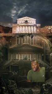
The One World Tartarians
The Greatest Civilization
Ever to Be Erased From History
James W. Lee
Chapter 2
Maps & Flags of the Great Tartary
.jpeg)
.jpeg)
.jpeg)
Tartary had to be multi-religious, and
multi-cultural is its vastness during various
moments in time. In 1652 Tartary appears to
have control over the North America. Also,
note the incredible detail of cities, rivers and
latitude and longitudes in these very detailed
maps that cover most of the world.


Washington State USA (1891)
Question #1: do you think it was possible to produce the below map by 1891, only 45 years
after the arrival of the first settlers?
Question #2: was it possible to settle an develop this territory, considering that up till 1880
there were only 75,000 , and up till 1890 only 357k people to do so? Here is the Washington State/
Territory historical census data populations:
Populations: 1845
- 0 *
1870 - 23,955
*
1880 - 75,116 *
1890 - 357,232
.jpeg)
1840 & 1846 Tartary

.jpeg)
It is also worth mentioning that
in the British Flag Table of 1783,
there are three different flags listed
as a flag of the Tsar of Moscow.
There is also an Imperial Flag of
Russia as well as multiple naval
flags. And all of them are proceeded
by a flag of the Viceroy of Russia.
Significance of the Viceroy is in
the definition of the term. A viceroy
is a regal official who runs a country, colony, city, province, or sub-national state, in the name of
and as the representative of the monarch of the territory. Our official history will probably say that
it was the Tsar of Russia who would appoint a viceroy of Moscow.
.jpeg)
I have reasons to doubt that.
Why is the flag of the Viceroy of Moscow positioned prior to any other Russian flag? Could it
be that the Viceroy of Moscow was superior to its Czar, and was “supervising” how this Tartarian
possession was being run?
Griffins, Symbol of The Great Tartaria
.jpeg)
.jpeg)
In Tartarian legend of this period, it was believed that griffins mated for life, and that when one
partner died, the other would live the rest of his/her without seeking another partner (perhaps
due to the fact that there weren’t many griffins around). This
has led to claims that the griffin was used by the Church as a
symbol against re-marriage. It is unclear, however, whether
this was the actual belief, or just a modern interpretation.
Although the griffin might seem like a creature conjured
from the imagination of mankind, there might actually be
some truth to this creature.
In this desert, the fossils of a dinosaur called the Protoceratops can be found. As these bones, especially the skull,
which has a bird-like beak, were exposed on the desert
floor, ancient observers may have interpreted them as proof that
such a hybrid creature once lived in the desert. Yet, it has been
shown that stories of the griffin have been around even before
the Silk Road was developed.
Interestingly, there are various hybrid creatures that are similar
to the griffin. For instance, the Lamassu was an Assyrian mythical
creature that had the head of a man, a body of a lion or bull, and
the wings of an eagle. This is also what the original Great Sphinx
of Egypt was designed as. According to biblical references, these
four animal faces represent the four domains of God’s rule: the man represents humanity; the
lion, wild animals; the ox, domestic animals; and the eagle, birds.
.jpeg)
These four creatures first appear together in the Judeo-Christian context in Ezekiel, which was
probably written around the third century BCE. In chapter 1, the prophet encounters fantastic
beings in the heavens: “As for the likeness of their faces, they four had the face of a man, and
the face of a lion, on the right side: and they four had the face of an ox on the left side; they four
also had the face of an eagle,”
Queen Khalifa ruled the Island of California with Griffins
which she fed the flesh of men to keep Spanish Invaders
away. She supposedly commanded a fleet of ships with
which she ruled and maintained peace in the surrounding
lands, and islands including Baja and Hawaii. She reportedly kept an aerial defense force of “griffins”, and other
fabulous animals which were native to California, trained
to defend the land against invaders. She even was said to
feed her griffins male flesh to repel male Spanish Invaders
aka Conquistadors.
She was so powerful she could project her imperial power
over the seas of the Mediterranean at will. The Esplandian narrates that Calafia maintained
cultural and trading contacts with the Muurs of Africa. It told of her wars in the mediterranean
seas, in Anatolia, the Byzantine empire and in southern Europe.
The Allegories of the Wizard of Oz
.jpeg)
Individual: a United States government Employee. (Title 5 USC §552(a)2). The Internal Revenue
Code (IRC) and all state tax codes are in harmony with the above definition of “individual”
by reference only. A corporation-of-one is an artificial person constructed by law; not a living,
breathing man or woman. An “individual” is a public corporate persona existing only in the
public (government) domain having been created by law, not by God.
The Strawman represented the legal strawman, filled with hay and no standing. In the 1930s
the all-capital-letter-written-name strawman — the newly created artificial “person” that has no
brain and speaks and acts for its once-upon-a-time sovereign, you and me — was created while
Americans were confused and distracted by the commotion caused by the introduction of the
New World Order of communistic socialism, to figure out that they even had a strawman with
which to contend. The scarecrow identified this strawman persona for Dorothy thusly: “Some
people without brains do an awful lot of talking. Of course, I’m not bright about doing things.”
.jpeg)
The setting of this allegory is in Kansas — the “heartland” of
America; the geographical center of the U.S.A. In came the twister
— the whirling confusion of the Great Depression, the stock-market
crash, the U.S. Bankruptcy, and the theft of America’s gold — that
whisked Dorothy and Toto up into the New Order of the World;
an artificial new dimension “somewhere, over the rainbow,” above
the solid ground of Kansas. When they landed in Oz, Dorothy
commented to her little dog Toto: “Toto? I have a feeling we’re
not in Kansas anymore . . .” Exactly! After the bankruptcy of the
United States, Kansas was no longer “Kansas” anymore, it is now “KS” — a two-capital-letter
federal postal designation that is part of the “federal zone,” designated by the Zone ImProvement
(ZIP) Code established by the bankrupt United States in 1933 — and Dorothy and Toto were
now “in this state.” The terms: “in this state,” “this state,” and “state” are deceptively defined
for tax jurisdiction purposes as the “District of Columbia,” a.k.a. the United States, Inc., or the
corporate United States.
The Tin-man, our Taxpayer-Identification-Number (TIN) man, is a hollow man of tin, a vessel,
or vehicle; newly created code words for our strawman. Just as the strawman has no brain, the
tin-man vessel/vehicle has no heart. Both are artificial persons. (person = persona = mask). One
of the definitions of “tin” found in Webster’s dictionary is “counterfeit.” The tin-man represents
the mechanical and heartless aspect of commerce and commercial law. Just like they say in the
Mafia, as they throw you overboard, your feet in concrete overshoes, “Nothing personal; [its]
just business.”
The lion in the story represents the “at-one-time” fearless American people as having lost their
courage. And after a round with the IRS, in “defending” your T-I-N man, dummy corporation,
vessel vehicle, individual employee, public corporation, all capital letters written name, artificial
person, strawman, you’d lose your courage, too. You perhaps haven’t known it, but the IRS has
been dealing with you all along via your Tin-Man under the hidden laws of commerce. Just like
the tin-man, “commerce” has no heart; it is heartless. To find the Wizard, you have to “follow
the yellow-brick road” (the gold-bar road.) Follow the trail of America’s stolen gold and you’ll
find the thief who stole it.
.jpeg)
As they all scampered toward the Emerald City — the city of green non-federal Federal Reserve
Notes (the new fiat money - money by decree) — we hear the Munchkins singing the glories of
the Wizard’s Creation: “You’re out of the woods, Your out of the dark, Your out of the night. Step
into the sun, Step into the light, Keep straight ahead for the most glorious place on the face of the
earth or the stars!” This jingle abounds with Illuminati/Luciferian metaphors regarding darkness
and light. The Wicked Witch of the West made her home in a round medieval Watchtower —
ancient symbol of The Knights Templar of Freemasonry who are given to practicing witchcraft
and are also credited to be the originators of modern banking, circa 1099 A.D.
.jpeg)
Vice Admiralty courts are courts established in the Queen’s possessions beyond the seas, with
jurisdiction over maritime causes and those relating to “prize.” The United States is now a colony
(a possession) of the English Crown, per a joint commercial venture agreement between the
colonies (the United States) and the Crown, which brought the United States back under British
ownership and rule, in 1933. But the American people had a “standing in law” as sovereigns,independent of any connection to the United States and the Crown. This
“standing in law” necessitated that the people be brought back under
British rule, quietly and one at a time — but the Commercial Process
of Redemption, through the UCC, will redeem us from this travesty.
All courts in America are Vice-Admiralty courts conducting the private
foreign commerce of the Crown. But there is commercial remedy in
Redemption-in-Law. http://www.freedom-school.com/
.jpeg)
The Flying Monkeys commanded by the Wicked Witch of the West
were really the Tartarian Griffins, sent East to halt the potential spread
of freedom to the individual and to continue in the Great Legal Deception of everyone being
“out to sea” under admiralty law. Those in power used very subtle imagery and prose to mock
the Tartarians.
Dorothy’s tactic was to drug them into unconsciousness by covering the countryside with
poppy flowers, poppies — the source of heroin, opium, and morphine — and then waltz in and
snatch the slippers. In other words, the best
way to loot the gold was to dull the senses of
the American people with a contrived crisis
(the Great Depression.) And of course, now
we have illicit street drugs, heroin, cocaine,
etc., and legal drugs such as Ridlin®, etc. and
television, bogus media dishing out control
propaganda, etc. …etc.
The poppy-drugs worked on Dorothy, the lion and Toto — the flesh-and-blood entities — but
had no effect on the scarecrow or the tin-man — the artificial entities. The two cried out for help,
and Glenda — the Good Witch of the North — answered their cries with a blanket of snow that
nullified the narcotic effect of the poppies on Dorothy, Toto, and the lion. As they all scampered
toward the Emerald City — the city of green non-federal Federal Reserve Notes (the new fiat
money - money by decree) — we hear the Munchkins singing the glories of the Wizard’s Creation:
“You’re out of the woods, Your out of the dark, Your out of the night. Step into the sun, Step into
the light, Keep straight ahead for the most glorious place on the face of the earth or the stars!”
.jpeg)

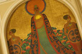
Often Griffins were portrayed as feminine, as the Feminine Divine of Nurture/Nature, Love,
Creativity and the “Attraction Principle” were all honored and revered and celebrated.55s
Chapter 3
Recent Mudfloods &
Liquefaction Events
Worldwide MudFloods


But now that we’ve been introduced to the concept of the
traveling Empire of Tartars (or
Tatars, the original spelling) and the
possibility they left beautiful cities in
their wake, perhaps these legends can
be re-examined.
.jpeg)


.jpeg)
Kansas City 1860
We can also ask ourselves what
happened to the sophisticated society
of Hyperborea that existed until the
mid-1500’s according to Mercator’s Map. We have all heard the legends
about the Seven Cities of Gold, even
the Lone Ranger and Tonto have them woven into their stories. The story we have been taught is
that the tricky natives lured the Spanish Invaders from their lands in Florida by telling them that
west beyond the Great River (which eventually became the Mississippi) that they would discover
vast elegant empires with citizens indulging in refined lifestyles and so much wealth that even
their most basic objects were crafted of gold and jewels.
Why All The Half-Floor First Floors?


Civilizations 200 ft. Below the Sea


Mysterious and strange, these ancient cities and
buildings have survived possibly centuries, protected
by water. Deeply hidden, some over 100 ft. below Sea
level, in the abyss because of natural phenomena,
they have been fundamental discovers for archeologists and they confirmed a lot of myths and legends.
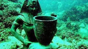


Cleopatra palace in Alexandria, discovered in 1998
is one of the most important finding about ancient
Egyptian civilization, containing a lot of daily life
objects and impressive and unique sculptures.


Mysterious pyramids of Yonaguni-Jima in Japan,
the beautiful city of Qiandao, China, and the amazing archeological park of Baiae in Italy. This
city literally collapsed underwater allegedly because of a volcanic earthquake. These pictures
here are mysterious and poetic, offering a view on a completely unknown world, unknown to
most in the “modern” world.
The Great Reset of 1811-1812

From December 16, 1811, through
March of 1812 there were over 2,000
earthquakes in the central Midwest,
and between 6,000-10,000 earthquakes
in the Bootheel of Missouri where
New Madrid is located near the junction of the Ohio and Mississippi Rivers.
In the known history of the world, no
other earthquakes have lasted so long
and resulted in so much damage as the
New Madrid earthquakes.
A Sequence of Three Main Shocks
in 1811-1812 of three very large earthquakes is usually referred to as the New
Madrid earthquakes, after the Missouri
town that was the largest settlement on
the Mississippi River between St. Louis, Missouri and Natchez, Mississippi. On the basis of the
large area of damage (600,000 square kilometers), the widespread area of perceptibility (5,000,000
square kilometers), and the complex physiographic changes that occurred, the New Madrid earthquakes of 1811-1812 rank as some of the largest in the United States since its settlement by Europeans.
They were by far the largest east of the Rocky Mountains in the U.S. and Canada. The area
of strong shaking associated with these shocks is two to three times as large as that of the 1964
Alaska earthquake and 10 times as large as that of the 1906 San Francisco earthquake.
The New Madrid earthquakes were felt as far away as Canada and the eastern seaboard, the
tremors caused church bells to ring in Boston and Philadelphia, the earth’s surface remained in a state
of constant motion for nearly four months, several towns were destroyed, an 18 by 5 mile lake was
created (Reelfoot Lake in Tennessee). The earthquakes felt strongly across 130,000 square miles
and moderately for a total of nearly 3 million miles. The effect was devastating and widespread.
The upheaval was so violent it created Reelfoot Lake fifteen miles south of New Madrid and
drowned the inhabitants of an entire Indian village along the Mississippi. The river amazingly
“ran backward” for several hours, which may have been a tsunami-like event exacerbated by
the eruption of groundwater for miles along the shore, which caused a rapid rise of the water
level in the riverbed.
The earthquakes were felt as far away as the White House, and it’s said that church bells in
Boston rang on their own. Shortly before the first earthquake, people reported strange behavior
by animals. Many animals were nervous and frightened. Domestic animals became wild, and
wild animals became tame. Snakes came out of the ground from hibernation. Flocks of ducks
and geese landed near people.

In 1811, a great bright comet appeared in
the skies. It was visible the naked eye for
around 260 days. In the USA, the comet was
named Tecumseh’s Comet and the Europeans called it “Napoleon’s Comet”.
The last time the comet had been witnessed
was during the reign of Egyptian Pharaoh
Ramses II, 3,065 years before. The arrival of
the Tecumseh’s comet was followed by the
New Madrid earthquakes, the biggest earthquakes in American history, events that are
linked to the Black Sun prophecy. Tecumseh
was an important Native American mystic, warrior and military leader of the Shawnee. He is
today remembered as a great hero who fought for freedom. His name ominously meant “Shooting
Star” or “He who walks across the sky.” Tecumseh’s brother, who was a religious leader, known
as “The Prophet,” had predicted a solar eclipse in 1806. William Henry Harrison, governor of
Indiana was worried the Prophet was becoming too popular and challenged him to produce a
miracle. The Prophet announced another solar eclipse occur and so it did, on September 17, 1811.
The Island of California


The inspiration for the word was likely “Khalif” or “Khalifa” which means “successor” in Arabic
but more specifically refers in Islam to a head of state or leader of the Muslims. Montalvo was
surely familiar with these words. Portions of Spain were ruled by the Moors (Tartarians!), who
were Muslim, from 757 to 1492. And it fits the story’s narrative. Montalvo’s novel was a fanciful
rehash of the struggle between Christians and Muslims during the crusades.
Was Wonder Woman Mythology
really Queen Califia’s lands?

When Wonder Woman’s homeland is first introduced in 1941, it is referred to as Paradise
Island, a secret and hidden island on Earth inhabited by the Amazons of myth. The Amazons
were given a break from
the hostilities and temptations of Man’s World,
and so were decreed to
start a new life improving
themselves by sequestering themselves to this
island away from ancient
Greece, after being
enslaved by Hercules.
With the island blessed
by the Olympian Gods,
no man was allowed to
physically set foot on it.
It was established that all
Amazons are adept at a discipline called “bullets and bracelets” in which they are able to deflect
bullets fired at them using the chain bands on their wrists.
It was originally implied, but not yet fully confirmed, that Paradise Island was located somewhere in the Pacific Ocean. Then in the 1970s television incarnation (as portrayed by Lynda
Carter), Paradise Island’s location was set in the Bermuda Triangle. And the 2009 animated movie
version had set it in the Aegean Sea.
.jpeg)
For centuries, the Amazons of Themyscira live in a perfect state of harmony with their surroundings, under a theocracy. They know no racism, although many consider Antiope’s Lost Tribe
of Amazons as little more than savages. They do not think in terms of male gender; the word
“policeman” is alien to them until Diana’s departure into the outside world. Homosexuality
is completely natural to them — while some Amazons are chaste, others have loving consorts.
Their city is composed entirely of Greco-Roman architecture from 1200 BCE, and they wear Greek
garb, togas, sandals, and period armor. The Amazons also all wear the Bracelets of Submission as
constant reminders of their Enslavement and obedience to their patrons, although only Diana is
able to deflect bullets with them. They are fervently religious, worshipping their gods as living
deities. Artemis is their primary goddess, and they worship her with a sacrifice of a deer. The
Amazons celebrate their creation each year in a Feast of Five, remembering the goddesses who
brought them to life.
The name “California” traces its origin
to a centuries old story about an island, full
of gold, run by black women who fed men
to their pet griffins. Like other Amazonian
legends, the island of California was a place
filled with strong, self-sufficient women who
solicited male attention completely on their
own terms. This story resonates in California,
which has a long history of gender roles
being reconstructed. And it is fitting that
this state, which has served as a frontier
for issues of race, gender and religion, gets
its name from a mythical story where race,
gender and religion collide. Finally, the story
of an island full of gold foreshadowed the
Gold Rush, which propelled the idea of the
California dream around the world.
A Muurish (African) Emperor Abu Bukari took 1,000 ships to the New World in the 1300s.
So Muurish navigators and sea men were highly sought in those days that the previously land bounded Europeans were in their infancy in navigational and maritime sciences. A black man
used to own the San Fernando Valley. That was Pio de Jesus Pico (1801-1894). He was also the
last Mexican governor of California. In total, in the 1800s, there were at least four black governors
of the state of California.
Califia is a part of California history, and she also reinforces the fact that when Cortes named
this place California, he had 300 black people with him. And throughout the whole Spanish
Mexican war, 40 percent of the population was black. In 1535, Cortés led an expedition back to
the land of Calafia or California and decided to be re-named it Santa Cruz. However, that name
did not stick, as the natives, and the Muurs and the black Indians and red Indians and so-called
whites continued to use the ancient and old name of the land “California”. Cortes himself and
his contemporaries appeared to have used the name too. In 1550 and 1556, the name appears
three times in reports about Cortés written by Giovanni Battista Ramusio. Thus, over the years
of increasing conquest, colonization and rape of the land of California, the ancient land of the
muurs has held onto its name and identity, in the knowledge that one day, it will be as it was in
the beginning. There are over 800 maps of California as an island up until the early 1800’s domiciled at the Stanford Research Library at Stanford University. And of course it is the Jesuits who
claimed the whole “Island of California” is a myth. Although some early maps showed California
on the mainland, a powerful refutation of the island theory came in 1701 when Jesuit explorer Eusebio
Kino crossed the Baja peninsula and, with a telescope, saw that it was part of the continent.
Over 250 maps from the 17th and 18th centuries show California as an island. The definitive catalog of “California as an Island” maps is “The Mapping of California as an Island” by
McLaughlin. The first map in McLaughlin’s catalog dates to 1621. Island maps continued into
the 1800s, in spite of Spanish explorer Father Kino demonstrating California’s connectedness
in 1705 by walking there from New Mexico. But since there were no accurate maps of the New World, map makers continued to supply the market using ancient sources. Hapgood attributes
the ancient sources to maps preserved in Constantinople and later distributed by Turks. (p.9)
That there were only a limited number of original sources is shown by their all falling into categories according to the features on the map. For example, some show the California island with
a flat top, others showing it with a “W” top. McLaughlin assigns maps to groups throughout
his catalog according to features such as the shape of the top of the island. Since no explorers
had mapped the California coast at that point, there was no way for map makers to know which
source was right. As it turns out, both sources are right, they were just mapped at different times
and different ocean levels.
Polk chronicles the extremely slow progress
of exploration along the California coast for the
next two centuries (“The Island of California, A
History of the Myth”, Dora Beale Polk). She relates
how Cortez mapped only the lower portion of
the Gulf of California. Alarcon sailed up the Gulf
to the Colorado River in 1540 and rowed up the
river a long way but left no map. The explorer
Onate reached the mouth of the Colorado at the
head of the Gulf in 1604, over a century after
Columbus’ voyage. (Polk p. 261) In the late 1500s, Spanish trade ships followed ocean currents
from the far east to the area of Mendocino, where they
turned south to Baja. But they would not venture near
the coast and so provided only limited information
on California geography. (Polk, p. 244) In 1603, on a
voyage cloaked in secrecy and plagued with misfortune,
Vizcaino explored the Pacific coast of California up to
Cape Blanco, Oregon, where they presumed a large
river was the sought-after passage to the Atlantic. (Polk,
p.257). In all these explorations, Polk emphasizes the
political pressure on explorers and map makers to find
that California was an island. It was in the best interest of
people like Cortez that California be an island, because
Cortez was promised governorship of the island.


The Island Coastline - Northern Portion
The Pacific coast has been pushed eastward about
200 miles. The area that was pushed eastward extends
from the top of the island at the north, to Point Concepcion at the south. This section of the coastline bears no
resemblance to today’s coastline. In the overlay map
to the left the northeast corner of the island forms a
point that is created by the mountain range ending at
the Willamete National Forest east of Eugene. The flat
top follows the visible break in the coastal range just
south of Eugene. Many “California as an Island” maps
from the 1600s and the 1700s show the north end of
the island as a distinct “M”. McLaughlin categorizes
maps by whether they have a “flat” or “indented” top
throughout his catalog of California as an island maps
(“The Mapping of California as an Island, an Illustrated Checklist”, Glen McLaughlin). The “M”
was the result of later pushing up of the coastal and Cascade ranges around Portland.
The salt lakes east of the northeast corner are evidence that there was a lot of saltwater left
there after the ocean receded. South on the Pacific side from the flat island top, we find the coastline from the top of the island to Point Concepcion extends 200 miles farther out into the Pacific
than it does today. Because the geography of the coastline is so different from the present day,
the Vingboons map offers no points of alignment with modern landmarks. Vingboons adorned
this section of the coast with many names of features that could not have had any resemblance
to what the early explorers saw, but rather assigned them the names given by the Spanish to the
modern features found by the Spanish at that latitude.
What caused this 200-mile eastward
movement of the coastline? While
changing ocean level played a small
part in the shape of the coast, the biggest
cause was plate movement of the Pacific
seafloor. Two significant rifts extend
across the Pacific, starting at the Hawaiian
Islands chain and meeting the continent
at Eureka on the north end and Point
Conception on the south, at Eureka by
the Murray Fracture zone, and at Point
Conception by the Mendocino Fracture
zone. These rifts do not stop at the Pacific coastline but rather continue to the east coast, the
northern rift to New York, and the southern rift to the active earthquake zone of North Carolina.
These rifts gradually buckled the continent from east to west, starting during the Flood with the
Appalachians. A Midwest uplift buried under Mississippi river valley sediment was the location
of the great earthquakes of 1811-1812. The Rockies were pushed up next, then the Wasatch range in
Utah and last the folded ridges of Nevada. Finally, after the Vingboons map was made, the Sierra Nevada and California Coastal ranges were pushed up. These two
ridges do not appear on an otherwise extremely accurate map. I
must assume they were not on the source maps because they did
not yet exist. The formation of these last two ranges pushed the
coastline of the map east by over 200 miles to where it is today.
The eastward shift can be seen in this map of California geology.
“Older Metamorphic and sedimentary rocks” are dark blue. There
is a sharp break in this rock between the Murray and Mendocino
rifts. Formation of the Sierra Nevada range pushed this block
east about 50 miles. The “Older Metamorphic and sedimentary
rocks” were pushed east into what became the Sierra Nevada’s.
The “Great Gold Rush of 1849” occurred due to the uplifting of
the Sierra Nevada Mountain range and revealed abundant gold
and silver on the surface of the ground. You could literally pick up
the nuggets without having to dig with a pickaxe. Therefore, ships
from as far away as China sailed to San Francisco and the wagon trains were able to cross the
Great Salt Lake, which up until that time, was still ocean fed. This is why you find ocean fossils
in the Great Salt Lake and no one was able to access California until the mid-1800’s!
The Great California Mud flood of 1862
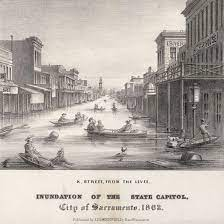
And while all this was going on The Great Flood of 1862 was the largest flood in the recorded
history of Oregon, Nevada, and California, occurring from December 1861 to January 1862. It
was preceded by weeks of continuous rains and snows in the very high elevations that began in
Oregon in November 1861 and continued into January 1862.

This was followed by a record amount of
rain from January 9–12, and contributed to a
flood that extended from the Columbia River
southward in western Oregon, and through
California to San Diego, and extended as far
inland as Idaho in the Washington Territory,
Nevada and Utah in the Utah Territory, and
Arizona in the western New Mexico Territory.
The event dumped an equivalent of 10 feet of
rainfall in California, in the form of rain and
snow, over a period of 43 days. Immense snowfalls in the mountains of the far western United
States caused more flooding in Idaho, Arizona,
New Mexico, and Sonora, Mexico the following
spring and summer as the snow melted.
The event was capped by a warm intense
storm that melted the high snow load. The resulting snowmelt flooded valleys, inundated or
swept away towns, mills, dams, flumes, houses, fences, and domestic animals, and ruined fields.
It has been described as the worst disaster ever to strike California.
Jesuits and Freemasons Founded the “New” California

In the winter of 1840, the Western Emigration Society was
founded in Missouri, with 500 pledging to trek west into
Mexico California. Members included Baldridge, Barnett,
Bartleson, Bidwell and Nye. Organized on 18 May 1841, Talbot
H. Green was elected president, John Bidwell secretary, and
John Bartleson captain. The group joined Father Pierre Jean De
Smet’s Jesuit missionary group, led by Thomas F. Fitzpatrick,
westward across South Pass along the Oregon Trail. That
trail took them past Courthouse and Jail Rocks, Chimney
Rock, Scotts Bluff, Fort Laramie, and Independence Rock.
The Bartleson-Bidwell party separated from Fitzpatrick, and
the missionary group, at Soda Springs on 11 Aug.
Some 152 years ago Freemason Brother Peter Lassen led
12 wagons from Missouri to California, forging the treacherous – and now infamous – Lassen Trail. After months of
hardship, he successfully delivered new settlers to Benton
City, the state’s northernmost community. On November 23,
1848, Levi Stowell was appointed master of the new lodge, and on November 15, 1849, the lodge
was formally organized under the charter. After meeting the requirements of the Grand Lodge
of California, Sacramento Lodge #40 was chartered on May 6, 1854 and assigned the number
40, signifying that it was the fortieth Lodge of Free and Accepted Masons to be chartered in the
state of California. Lafayette Lodge No. 126 was chartered by the Grand Lodge of California on
May 13, 1858. It is located in Sebastopol California, originally a farming community north of San
Francisco. To this day, La Fayette Lodge maintains the traditions of a small-town community.
Jesuit Joseph Justus Scaliger (1540 – 1609)
Chief Architect of Falsifying Modern History

Scaliger was a French Jesuit religious leader and scholar, known for expanding the
notion of classical history from Greek and ancient Roman history to include Persian, Babylonian,
Jewish and ancient Egyptian history. In 1601 Gaspar Scioppius, then in the service of the Jesuits
published his Scaliger Hypobolimaeus (“The Supposititious Scaliger”), a
quarto volume of more than four hundred pages. The author purports
to point out five hundred lies in the Epistola de vetustate of Scaliger. The
pressure of the Scaligerian chronology and all of these oddities brings
historians to the conclusion that:
Jesuits, Knights Templar and Freemasons well established
in San Francisco by 1849
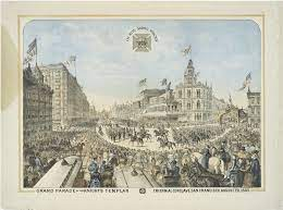
View of the Knights
Templar parade in San Francisco, August 20th, 1883. It
was built in 1905 and 1906-
1907. The building has been
home to two institutions,
the Knights Templar and the
Baptist Church. The building
was originally built for the
Golden Gate Commandery
#16 of the Knights Templar,
a masonic order at the turn
of the century. The building
was originally built for the
Golden Gate Commandery
#16 of the Knights Templar.
“The Middle Ages were the time when all idea of chronological consequentiality had been lost: monks with crosses and thuribles at the funeral
of Alexander the Great, Catilina attending mass... Orpheus becomes a
contemporary of Aeneas, Sardanapal a Greek king, and Julian the Apostate
- a Papal chaplain. Everything acquires a hue of fantasy in this world [this
perplexes the modern historian greatly - A. F.. The most blatant anachronisms and the strangest fancies coexist peacefully.”
San Francisco Mason Temple


The first Masonic lodge, at 1 Montgomery Street, was built in 1860 and, of course, burned
down in the 1906 fire. On 1911, the Masonic Temple Association laid a 12-ton cornerstone (the
largest ever in California at that time) for the new building. Two years later, (man these guys could
erect back then!), a grand parade of 8,000 Masons, with Knights Templar on horseback, marked
the dedication


Memories of the 1904 Grand Encampment Triennial
by W. Bruce Pruitt, KGC, Right Eminent
Past Grand Commander, California

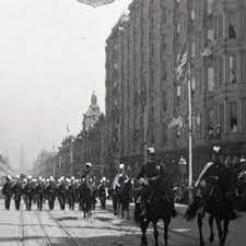
The most unforgettable event that took
place in the city of San Francisco, California, in the year 1906 was the infamous
earthquake and fire. However, two years
earlier, in 1904, the most significant and
memorable event was the very impressive
assembly of Knights Templar of the Grand
Encampment of the United States. San
Francisco was literally “turned over” to
host the twenty-ninth Triennial. Only a few
examples of the opulent treatment given by
the city will demonstrate the importance
attributed to the event. Market Street, the
major street of San Francisco, was lined
with columns capped by Templar crosses.
The Ferry Building, at the foot of Market
Street and perhaps the most dominant
structure at that time, was outlined with
lights and had a lighted Knight Templar
cross on the side facing the city.
The Grand Lodge of California building
was outlined at every corner with lighting
including the square and compasses, Templar cross, cross and crown, etc. (This beautiful structure,
on Market Street, was destroyed by the earthquake and fire two years later.) Golden Gate Park
was profuse with floral arrangements forming Masonic symbols of all types. Business sessions
were held in Golden Gate Hall, and the San Francisco Pavilion was greatly decorated for events.
The festivities extended from August 31 to September 6 and culminated with an amazing parade
through the length of Market St. to Van Ness Avenue. Many, if not all, attending Commanderies
produced souvenir medals to commemorate the experience. One personal enjoyment engaged
in by the Knights was to exchange medals and accumulate a collection to take back home.
The presiding Most Eminent Grand Master was Sir Knight Henry Bates Stoddard of Texas. He
was greeted in Oakland by the Grand Commander of California, Past Grand Master Reuben H.
Lloyd, the Commanders of California Commandery No. 1 and Golden Gate Commandery No
16, and an escort of Sir Knights. He then proceeded across San Francisco Bay by ferry to the Ferry
Building, where he was met by an even more elaborate escort. The record states: “At the Ferry
Station, companies A, B, C, D, and E of California Commandery mounted on finely caparisoned
black chargers and under the command of Sir Knight Rueben P. Hurlbut, Captain General (on a
snow-white charger -- ed.) were drawn up in line for escort duty.” The Grand Master, Past Grand
Master, Grand Commander, and Commander of California Commandery proceeded in a carriage
drawn by four white horses. Several other carriages followed. The delegation from Great Britain
was given special attention:

”Great deference was paid
to the distinguished delegation from the Great Priory of
England during the stay of
the members in San Francisco.
The visit itself was a distinction, representing the fraternal
relations existing between
the governing bodies of the
greatest two Grand Jurisdictions of Templars in the world.
In another sense it was highly
representative in that in his official capacity the Earl of Euston
was the personal representative
of Edward VII, King of England,
who for many years was the
active head of Craft Masonry
in England and who has ever
been a patron of the Order in
that jurisdiction.”

The drill competition was held on the multi-acre Recreation Ground of Golden Gate Park. Awards
were won by Ivanhoe Commandery No. 24 of Milwaukee, Wisconsin; Malta Commandery No,
20. of Binghamton, New York; and Louisville Commandery No. 2 of Louisville, Kentucky. The
launching of the armored cruiser Milwaukee was timed to occur during the time of the Conclave.
It took place at the Union Iron Works along the shoreline of San Francisco Bay. Naturally it was
of special interest to the delegation from the state of Wisconsin. A beautiful, leather-bound record
was produced to commemorate this Triennial. That book is truly a treasure and a collector’s item.
A review of the photographs in this volume is the only way one can appreciate in any way the
extent of effort and involvement that went into this assembly. Those pictures help one to enjoy,
in particular, the final parade of Sir Knights. The number of mounted companies, the sizes of
the delegations, and the number of spectators lining the
streets make one really appreciate those “glory days”
of Templary. Oakland Commandery No. 11 seemed to
extend for over a block. San Jose Commandery No. 10
was almost two blocks long. California Commandery was
resplendent in their unique uniform and made up a fully
mounted troop. Even though there were, of course, larger
groups from California, every Grand Commandery made
an impressive appearance. The Grand Commandery of
Pennsylvania, mounted on matching black steeds, did
their part to impress the on-lookers.
The Legend of San Francisco and Conflicting Population Numbers
Remember, the only way to access SF was from the South or by water,
so all materials had to be hauled in and that California Statehood was not
reached until 1850. The 1850 U.S. Federal Census tallied California’s population at 92,597. This illustrates the population consensus of San Francisco,
which clearly shows that either the consensus is in error by a great margin
given the photographic images of the 1850’s – 1900’s, or the Tartarians were
there already well established.
And the story goes… Then in 1846 the USA annexed California. On 9 July
1846 USS Portsmouth sailed into San Francisco Bay and sailors and marines
went ashore and raised the US flag. The little settlement of Yerba Buena
was renamed San Francisco (after the bay) on
30 January 1847. At
that time San Francisco
only had a population
of about 800. In 1848 a man named James
Marshall discovered gold. News of the find
reached New York in December 1848. As a
result people went to San Francisco in their
thousands and the population boomed. In
1849 the population of San Francisco reached
25,000. That first wave of settlers included
many southerners who brought slaves with
them. Even after California was granted statehood in 1850 as a “free” state, several thousand
people of African descent were held in slavery
with the backing of fugitive slave laws passed by the California legislature and approved by the
California supreme court. But a growing majority of California’s white men, the only ones who
could vote, were embracing the “free soil” ideology of the anti-slavery wing of the Democratic
Party. The commitment to free white labor meant that any other group,
for example, the thousands of Mexicans, Chileans, Peruvians, and
other Spanish-speakers who arrived early to the gold diggings, had
to be defined as occupying a different category of work. The push for
a “foreign miner’s tax” that lasted until 1852 was designed to drive
out the so-called peones, or peons, men who were paid a pittance
and sent the products of their labor to their patrones, or bosses. The
Spanish-speaking gold miners were defined as less than white men
by this argument, and thus subject to violent expulsion. After 1852,
when most Spanish-speaking miners had departed, the target of
white miners was shifted to the Chinese miners. Before long a new
claim was being made about the Chinese workers who had signed
contracts and come to work in California: they were “coolies.”

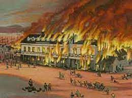
And, of course, as we see everywhere, fires burning buildings in the 1850’s and beyond.
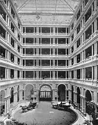

Grand Victoria & Palace Hotels-1880's


Palace Hotel 1890s

Frequent fires shaped the development of both San Francisco and Sacramento, and the years
of 1849 to 1851 were a particularly fiery time in the history of both towns.

My novel takes place
between 1848 and 1850. Sacramento is
one of the primary settings of the novel,
and some scenes are set in San Francisco
as well. So I decided learning something
about the San Francisco and Sacramento
fires would be good background. This
post focuses on San Francisco.
Santa Rosa, California was founded
in 1833 and named after Saint Rose of
Lima. Before the arrival of Jesuits, the
Santa Rosa Plain was home to a strong
and populous tribe of Pomo natives
known as the Bitakomtara. The Bitakomtara controlled the area closely, barring
passage to others until permission was
arranged. Those who entered without
permission were subject to harsh penalties. The tribe gathered at ceremonial times on Santa Rosa
Creek near present-day Spring Lake Regional Park. Upon the arrival of Europeans, the Pomos were
decimated by smallpox brought from Europe. By 1900 the Pomo population decreased by 95%.
Just down the road is the towns of Sebastapool and Occidental. Remember, California was
‘founded’ in 1850’s and is home to Bohemian Grove were world elite power gather each year in the
summer since 1872.. By 1863, there
was already railroads to through
these towns whose populations were
under 5,000 people.

Interestingly, Sevastopol, in Russia
laid claim to the possible to one of
the classic sieges of all time. The city
of Sevastopol was the home of the
Tsar’s Black Sea Fleet, which threatened the Mediterranean. The Russian
field army withdrew before the allies
could encircle it. The siege was the
culminating struggle for the strategic
Russian port in 1854–55 and was the
final episode in the Crimean War.
1850’s Los Angeles, California….
More Tartary Grand Designs


The first Our Lady of Sorrows Church
was consecrated July 29, 1855, and the
Jesuits have served at the parish since 1908.
Blessed Sacrament Church in Hollywood, established in 1904, came under
Jesuit administration in 1914, beginning
with Father William Deeney pastor,
the former president of Loyola College
(now Loyola Marymount University).
And Dolores Mission in Boyle Heights
— at 68, the “baby” of the group — has
been administered by the Jesuits since
1980. A fourth parish with Jesuit history,
St. Ignatius of Loyola in Highland Park,
was founded in 1911 by Jesuit priests
under the leadership of Bishop Thomas
Conaty of the Monterey-Los Angeles
Diocese.
79s next-The Tartarian Culture
FAIR USE NOTICE
This site contains copyrighted material the use of which has not always been specifically authorized by the copyright owner. As a journalist, I am making such material available in my efforts to advance understanding of artistic, cultural, historic, religious and political issues. I believe this constitutes a 'fair use' of any such copyrighted material as provided for in section 107 of the US Copyright Law.
In accordance with Title 17 U.S.C. Section 107, the material on this site is distributed without profit to those who have expressed a prior interest in receiving the included information for research and educational purposes. Copyrighted material can be removed on the request of the owner.


No comments:
Post a Comment