The Ancient Giants Who Ruled America
by Richard J Dewhurst
6
CITIES IN CIRCLES AND LINES
In the study of ancient human beings, the presence of cities is regarded as one of the most significant
indicators of civilization. This sampling of stories from around the nation makes it clear that ancient
America was home to significant urban centers, connected by trade. What is often not understood is that
many mound builder centers featured traditional houses that surrounded the ceremonial mounds and that
most of the major sites had roads, gates, and walls surrounding them. In addition, evidence of sewage
systems and canals has been detected at various sites across the country. In some cases the towns were
also manufacturing centers and show signs of high trade and commerce of great sophistication.
THE POVERTY POINT INDUSTRIAL METROPOLIS
Although the Cahokia mound complex near St. Louis is considered the major mound site on the
Mississippi River, the Poverty Point earthworks in Louisiana is the most ancient temple site and trading
center on the Mississippi River. As the vast extent of this site has been uncovered, its primacy as the
major trading site of ancient America has gradually gained credence with traditional scholars. Poverty
Point is constructed entirely of earthworks. The core of the site measures approximately five hundred
acres (two square kilometers), although archaeological investigations have shown that the total
occupation area extended for more than three miles (five kilometers) along the river terrace. The
monumental construction consists of a group of six concentric, crescent-shaped ridge earthworks, divided
by five aisles radiating from the center at the riverbank. The site also has several mounds, both on the
outside and inside of the ring earthworks. The name Poverty Point came from the plantation that once
surrounded the site. The United States nominated Poverty Point for inclusion on the United Nations
Educational, Scientific, and Cultural Organization’s (UNESCO) World Heritage List in January 2013.
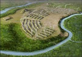
Fig. 6.1. Poverty Point
Most of the artifacts found at Poverty Point are small baked shapes made of loess. They are usually
shaped like balls, bicones, or ropes, all of which have been described as Poverty Point objects, or PPOs.
Archaeologists have long debated their uses and have concluded that the fired-earth objects were used in
cooking. When placed in earth ovens, the objects were shown to hold heat. An alternate way of heating up
food before pottery was to stone boil. The soil of the lower Mississippi Valley at Poverty Point does not
contain proper pebbles, so the manufacture of artificial stones was necessary.
In recent years, the theory that these anomalous clay balls, fire pits, and other PPOs were used for
cooking has come under intense debate, and more recent discoveries linking this site to the copper producing region of the Great Lakes has led some scholars to posit that what was really going on at
Poverty Point was actually the refining of copper for trade goods, the theory being that raw copper was
brought down from Michigan during the summer months and then refined for manufacture and trade during
the winter in the warmer climate of Louisiana.
LOST CITY IN ONTARIO
A report from 1871 notes that a lost city was found on a farm in Dunnville, Ontario, in association with
two tons of charcoal and various implements that indicated the site of an ancient forge.
GIANT SKULLS WITH PERFECT TEETH
DAILY TELEGRAPH, TORONTO, ONTARIO,
AUGUST 23, 1871
Dunnville, Ontario: There is not the slightest doubt that the remains of a lost city are on this farm. At
various times within the past years, the remains of mud houses with their chimneys had been found and
there are dozens of pits of a similar kind to that just unearthed, though much smaller, in the place which
has been discovered before, though the fact has not been made public hitherto. The remains of a
blacksmith’s shop, containing two tons of charcoal and various implements, were turned up a few months
ago.
The farm, which consists of 150 acres, has been cultivated for nearly a century and was covered with a
thick growth of pine, so that it must have been ages ago since the remains were deposited there. The skulls
of the skeletons are of an enormous size and all manner of shapes, about half as large again as are now to
be seen. The teeth in most of them are still in an almost perfect state of preservation, though they soon fall
out when exposed to the air.
It is supposed that there is gold or silver in large quantities to be found in the premises, as mineral rods
have invariably, when tested, pointed to a certain spot and a few yards from where the last batch of
skeletons was found directly under the apple tree. Some large shells, supposed to have been used for
holding water, which were also found in the pit, were almost petrified. There is no doubt that if there is a
scheme of exploration carried on thoroughly, the result would be highly interesting. A good deal of
excitement exists in the neighborhood, and many visitors call at the farm daily.
The skulls and bones of the giants are fast disappearing, being taken away by curiosity hunters. It is the
intention of Mr. Fredinburg to cover the pit up very soon. The pit is ghastly in the extreme. The farm is
skirted on the north by the Grand River. The pit is close to the banks, but marks are there to show where
the gold or silver treasure is supposed to be under. From the appearance of the skulls, it would seem that
their possessors died a violent death, as many of them were broken and dented.
The axes are shaped like tomahawks, small, but keen, instruments. The beads are all of stone and of all
sizes and shapes. The pipes are not unlike in shape the cutty pipe, and several of them are engraved with
dogs’ heads. They have not lost their virtue for smoking. Some people profess to believe that the locality
of the Fredinburg farm was formerly an Indian burial place, but the enormous stature of the skeletons and
the fact that pine trees of centuries growth covered the spot go far to disprove this idea.
OHIO ESTIMATED TO HAVE TEN THOUSAND MOUNDS
NEW YORK TRIBUNE, 1874
The first settlers of the Ohio and Mississippi Valleys found various forms of earthworks in the solitudes
of the wilderness overgrown with dense forests. It is said that Ohio alone has 10,000 of these in the form of mounds of various sizes, and 1,500 enclosures are scattered through the state.
They are found in Illinois, Wisconsin, and other Western States, and in the Gulf States, varying in size.
Some are small hillocks two or three feet high, while others assume almost pyramidal magnitude, like the
mound in Cahokia, Ill., which has a base of more than five acres in area and a height of ninety feet.
One of the most elaborate of all these works is located in Newark, Ohio. It is labyrinthine in structure,
containing some fifteen miles of embankment, and after years of investigation archaeologists can do no
more than surmise as to what its uses were.
Clearly it cannot have been built for architectural purposes, for the enclosures of which it principally
consists have the ditches on the inside of the embankment, while the outside presents no visible obstacle
to an invading army.
100-FOOT GATEWAY
One of the largest of the enclosures is known as “Old Fort” and stands one and a half miles southwest of
the city of Newark. It consists of a circular embankment more than a mile in circumference, entirely
unbroken except on the side toward the city, where a mammoth gateway of a hundred feet [in width] was
constructed by the builders. On each side of this passage, the ends of the embankment projected a little
from the center of the enclosure, and rose to a height of twenty-five feet, while the general height is about
eighteen. Upon this embankment and within the ditch on the inside, the trees are as large as those upon the
undisturbed portion of the ground around and within the fort. The citizen still lives in Newark who cut an
oak tree upon this bank sixty years ago which measured 650 rings of annual growth.
PARALLEL MOUNDS LEAD TO
OCTAGONAL CENTRAL SQUARE
From this mammoth gateway, two parallel lines of earth, a few rods apart, lead to a rectangular enclosure
over half a mile to the Northeast, which has an area of about twenty acres; beyond which, nearer the city,
are still other works, traces of which are obliterated.
From this network near the city, two sets of parallel walls run west more than two miles, move to
another enclosure in the form of an octagon, containing about fifty acres, to the southwest of which, and
almost adjoining it, is another circle about equal in size to “the Old Fort.” Both of these are situated on a
range of hills.
25-FOOT STONE WATCHTOWER
The ploughshare has performed its work of demolition to some extent upon the walls upon some of these
latter enclosures with the exception of one point on the circular embankment. This consists of earth and
stone somewhat irregularly built to a height of twenty-five feet, and, as it lies in the extreme southwest of
the whole system of works, it is thought by some that this was the watchtower or signal station on the
west.
ONE THOUSAND YEARS OF FOREST
GROWTH COVER THE SITE
When, by whom, and for what purpose these mammoth works were built, are puzzles which have always
baffled the skill of archaeologists. It is evident they were built long ages ago, for, where the timber has
not been removed by civilized man, as in the case of the “Old Fort,” dense forests covered the works,
which must have required one thousand years to grow where they now stand. It is not altogether
unreasonable to suppose that generation after generation of forests has grown and decayed on this soil
since it was built by the dusky savages into the form we now find it.
THE WHEATFIELD MOUND OF PENNSYLVANIA,
FIRST DESCRIBED IN 1806
An ancient mound in West Wheatfield Township, a short distance north of Robinson, Pennsylvania, was
known to the earliest settlers as Fort Hill. Earlier digs at the Fort Hill site uncovered textiles of a finely
woven nature that did not match those of the local Indians, as well as a number of carved and hollowed
stone instruments whose use was unknown at the time they were dug up. The earliest published
description is from 1806.
Wheatfield Town History, 1806
In Wheatfield Township there is a remarkable mound from which several antiques have been dug,
consisting of a sort of stone serpent, five inches in diameter; part of the entablature of a column, both
rudely carved, in form of diamond and leaves; an earthen urn with ashes, and many others of which
we have no account. It was thought that it was the ruins of an ancient Indian Temple.
Arm’s history states that the mound described was on the inside of “Fort Hill” and that there were
found at an early date pottery fragments of much finer texture than that made by the historic Indians;
also stones both large and small, of peculiar shapes, carved and hollowed.
CIRCULAR VILLAGES AMID THE TREES
Before the encroachment of modern civilization, the area of western Pennsylvania leading all the way into
Indiana was described as a vast sea of trees and high grass that was teaming with wild life and ample
plants and herbs for a wide variety of uses. The following description of a circle mound population of
two hundred people was first recounted in a court in 1731.
An official report from Jonas Davenport and James LeTort to the Pennsylvania Provisional Council
stated that there were three villages along Conemaugh Creek, composed of approximately forty-five
families, with a population of around two hundred people. Typical of these kinds of villages, all three
were contained within their own earthen rings. Jonas Davenport and James LeTort, two of the very
earliest Europeans to trade with the Indians in Western Pennsylvania, reported in an affidavit before the
Pennsylvania Provisional Council, October 29, 1731, that “on Conemaugh Creek there were three
Shawanese towns” having 45 families and 200 men. Their Chief was Okowala (also Okowelah or
Ocowellos) who was suspected of being a “favourer of ye French interest.”
In its original wilderness condition at the beginning of historic times, Western Pennsylvania was
covered by a vast sea of trees. Many travelers wrote of the view from one another of the mountain ridges
as a sea of treetops or the waves of the sea. Here and there were small natural areas of shrubs and high
grass. The area west of Indiana, according to the earliest pioneers, was one of these and so was a portion
of the southeastern area of Indiana County known as “The Wheatfields.”
In the northeastern part of the county were huge white pines, 200 feet or more high along with many
hemlocks. In some places the shade of the tall trees was so dense that sunlight seldom ever penetrated.
One could walk fairly easily through such mighty forests, but the oppressive silence and the sunless gloom
caused many travelers to dread them, and they wrote of them as “Shades of Death.”
The three ancient towns are thought to have been Conemaugh Old Town (now Johnstown), Black Legs
Town, and Keekenepaulin’s Town south of the Conemaugh near Loyalhanna Creek.
Davenport and LeTort also mentioned that the Delawares along the Conemaugh numbered 20 families,
and 60 men; their Chiefs being Captain Hill, or “Alaymacapy” and “Kykenhammo.” Also named as living
in the area was “Sypous, a Dingoe.” There seems to have been an Indian town north of New Florence.
The Robert Hinkson tract of 301 acres was described as “the old town . . . situate on the north side of
Conemaugh opposite Squirrel Hill (the name of the Indian town at New Florence). The Joseph Culbertson
Warrantee Survey (B 23-22) indicates an ‘Old Indian Town’ north of the Conemaugh.”

Fig. 6.3. A carving of an otter. Illustration from Ancient Monuments of the Mississippi Valley by Ephraim Squier and Edwin
Davis
In shape the village was roughly circular consisting of two parallel stockades, the outer one 450 feet
in diameter and the inner 430 feet. This fact was ascertained by the finding of rows of “post molds,”
each mold easily identifiable because of the darker soil in it as contrasted with the lighter
surrounding subsoil. There was a plaza area in the center of the village. Refuse pits filled with debris
were here and there.
The Indian huts were arranged in a rough circle just within the stockade, and, as shown by the post
molds, were from 18 to 20 feet in diameter, having a very narrow entrance less than two feet wide.
Inside was a fire pit. Attached to or very near each hut, was a bark-covered, pear-shaped food
storage pit. It is believed that tender young saplings were placed in each post hole, arched toward the
center, tied at the top, and the whole covered by bark. The staple food seems to have been maize,
probably grown in small plots outside the village. Other common foods were fish and mussels, and
the meat of animals, particularly deer and elk.
The streams were then clean and sparkling, and fish were abundant. In the smaller creeks were
speckled trout; in the larger ones yellow and black bass, white perch, buffalo fish, and mullets. In the
rivers were pike, sturgeon, and salmon. Some specimens were as much as four feet long and 35
pounds. Other animals have been noted in connection with the archaeological excavations at the site
of the late Prehistoric Indian village near Blairsville.
Other animals known to have been here were gray and black squirrels. The number of panthers is
thought to have been rather few. Even more scared were the wood buffalos, larger than their
Western kin (nearly a ton in weight), having no hump and being more nearly black in color, with
shorter hair and large hind quarters. The extensive and lucrative fur trade caused the beaver to
disappear from the local area.
THE GIANTS CLEARED THE FOREST
The claims of the local Indians of Pennsylvania that they did not clear the wide swaths of forest in the
area echo the claims of other Indian tribes across the United States, who also claim no part in the
construction of the ancient earthworks found in their tribal domains. The local Indians’ claim that giants
were responsible for the clearing of forestland and construction of huge earthworks is echoed throughout
the United States by widely separated, unrelated Indian tribes.
EXTRA GIANTS: FOUND ON THE
NEW YORK-PENNSYLVANIA STATE LINE
PHILADELPHIA TIMES, JUNE 27, 1885
"Why this man was ten or twelve feet high. Thunder and lightning!” exclaimed Mr. Porter in astonishment.
The first speaker, who has won local distinction as a scientist, reiterated his assertion. J. H. Porter has a
farm near Northeast, not many miles from where the Lake Shore Railroad crosses the New York state
boundary line. Early this week some workmen in Mr. Porter’s employ came upon the entrance to a cave
and on entering it found heaps of human bones within. Many skeletons were complete and specimens of
the find were brought out and exhibited to the naturalists and archaeologists of the neighborhood. They
informed the wondering bystanders that the remains were unmistakably those of giants. The entire village
of Northeast was aroused by the discovery and today hundreds of people from this city took advantage of
their holiday to visit the scene. . . . So far about 150 giant skeletons of powerful proportions have been
exhumed and indications point to a second cave eastward, which may probably contain as many more.
Scientists who have exhumed skeletons and made careful measurements of the bones say that they are the
remains of a race of gigantic creatures, compared with which our tallest men would appear pygmies.
History of Crawford County Pennsylvania, 1850
When first visited by the whites, in the valley of French Creek were old meadows, destitute of trees
and covered by long wild grass and herbage resembling the prairies. By whom these lands were
originally cleared will probably forever remain a matter of uncertainty. The Indians alleged that the
work had not been done by them. A tradition among them attributed it to a larger and more powerful
race of inhabitants who had pre-occupied the country.
NUMEROUS MOUNDS AND INDIAN RELICS TO
BE FOUND ALONG THE
CHEAT RIVER ABOUT
HORSESHOE BEND IN TUCKER COUNTY
BY HUGH MAXWELL
RALEIGH HERALD, OCTOBER 4, 1906
The center of the prehistoric Indian settlement, which evidently contained a large population, was on a
prime piece of bottom land on the Cheat River, in a bend of the stream enclosing one thousand acres or
more. It lies in Tucker County, two miles above the village of St. George, and has always been known as
Horse Shoe Bend. The tract contained two towns, the sites of which may still be distinguished by the rank
vegetation, which flourishes in a soil made fertile by the accumulation of bones and other camp life.
The town sites are about a mile apart. The last inhabitant left them as much as 250 years ago, and
perhaps much longer ago, if the evidence handed from the first settlers is reliable, and there is no
occasion to doubt it.
The lower town site lies opposite Sycamore Island, on the southwest bank of the Cheat River, a third of
a mile below the mouth of Horse Shoe Run, and about an equal distance from the grave which I opened
last Wednesday, mentioned in a former article. The town site is on the farm of Joshua Parsons.
The river is rapidly encroaching on its banks at that place, and has been doing so for more than 100
years. It has washed away the greater part of the land that the village stood on and will wash it all away
in the next few years. The soil at that place is 14 feet deep.
A STOREHOUSE OF INDIAN RELICS
This region along the Cheat River, above and below the Horse Shoe, is a storehouse of Indian
archaeology. It is covered with sites of camps and towns with graves and mounds. Many relics have
been picked up in the past, but few were saved. If all had been preserved they would tell a tale of the
dim past that would astound the people of today.
TWO ACRES OF RECTANGULAR STONES
The site of the principal village on the Cheat River, near this place, had a particular nature nearly
unknown elsewhere in this region.
When Captain James Parsons in 1769 made his homestead on the river bottom, which is enclosed in the
great bend of Cheat River, and is called the Horse Shoe, he found a plot of ground, rudely quadrilateral in
shape, and covering about two acres, so stony as to be unfit for cultivation. He therefore left it un-cleared
until all of his other hundreds of acres had been redeemed from the forest.
PARALLEL ROWS OF STONES FOUND
When the land became valuable, he cut off the trees and began hauling away the stone. He then discovered
that all of the stones were on the surface of the ground, while a deep soil lay beneath. What surprised him more was to find that the stones had been laid in parallel rows, and so regularly that he was convinced
that it was the work of men.
The stones were worn river rocks, carried no doubt, from the stream which flowed immediately by the
spot. The village had been long deserted, even in 1769, when first seen by white men. That was proved
by the fact that large trees had grown up through the stone pavement, pushing the rocks aside with their
trunks. There were sycamore trees six feet in diameter, and walnuts and oaks nearly as large. Their ages
could not have been less than 300 and may have been 500 years. It is not probable that the trees would
grow there while the Indians occupied the place. It is, therefore, not unreasonable to presume that we
have here the remains of a town antedating the discovery of America by Columbus.
GIANT TOWN
The first recorded settlement on that river bottom [Cheat River] was made in 1769, and there was built
the fort in which the settlers found shelter during the Denmore War of 1774. The old settlers called the
place where the Indian village stood “The Giant Town.” This was not because the town was larger, but
from the fact that the skeleton of a very large man was unearthed at that place about 180 years ago. The
fact is as well authenticated as any event can be that depends to some extent on tradition.
In the year 1774, or about that time, James Parsons was walking along the river bank at that place (the
Cheat River) and discovered the bones protruding from a bank where a recent flood had washed away the
soil. He pulled out the thigh bones of a man, and adjusting the bones to his own leg for comparison he
found that the bone was seven inches longer than his own. He was six feet tall.
He pulled out other bones until he had the greater part of a skeleton from the knees upward. . . . The
lower jaw bone fitted over the outside of his face. He made a partial reconstruction of the skeleton and
was sure the man when alive was eight feet tall.
TRADITIONS OF GIANTS
Traditions of giants should be accepted with about the same caution as we accept the measurements of
Goliath, who was said to be 11 feet tall. There is no special reason to dispute the truth of Captain James
Parsons’ statement concerning the bones. He was a man well known in his day, and was reliable. He was
frequently spoken of in the frontier histories.
PLEA TO SAVE THE MOUNDS
On the occasion of my present visit I was disappointed and disgusted to find that the owner of the land
had attacked it with a plow and scraper, and had leveled it (the mound). He wanted the space for
agricultural purposes. A few sheaves of oats were worth more to him than a mound dating back to a
prehistoric people. Such is the sentiment that one all too often finds.
The past has no value in comparison with a crop of oats or a bushel of corn. Such people would break
up the ruins of Baalbek for material to macadamize a road.
The utter want of appreciation of things that cannot be eaten, worn, or sold, was illustrated in the case
of a large earthen mound on the second terrace above both of the village sites, and nearly between them. I
had expected to ask the permission of the owner of the land to open it; but I heard it had been opened
some months ago. When I asked what was found in it, the answer was: “Not a cent; only some trash.”
The people who dug it open expected to find money in it, and failing to find that, they saw no earthly
value in the “trash” that was turned up by the shovels. Yet who knows what may have been the bits of
weapon wampum, or of stone, bone, or copper jewelry, which would have thrown light on the history and
habits of the people who lived and died here at a time of which no syllable has been recorded.
In 1893, the Bureau of American Ethnology at the Smithsonian reported finding a very ancient Indian
village near Poplar Bluff, Missouri. According to the article below, over one hundred skeletons were
recovered, including those of a chief who measured seven feet, eight inches tall.
MISSOURI MOUNDS ARE A GOLDMINE
ASSOCIATED PRESS, OCTOBER 5, 1964
The farm, long known to be an archaeological gold mine, is identified in archaeological circles as
“Koehler’s Fort.” Diggings were made in 1893, by the Bureau of American Ethnology (of the
Smithsonian). Findings established that the Koehler farm was the site of a village populated by 500
Indians of the Middle Mississippian culture. These aborigines pre-dated the tribal American Indian.
THEY LIVED IN HOUSES
They lived in daub and wattle houses under a system of organized government. Identified with the mound
builders of Cahokia, Illinois, whose culture extends as far southeast as Georgia, their culture was a peak
in civilization.
HOW THE PREHISTORIC RESIDENTS OF IOWA LIVED
IOWA CITY PRESS CITIZEN, JANUARY 13, 1939
Professor Charles R. Keyes of Cornell and director of the Iowa Archaeological Survey, in association
with the WPA: “The prehistoric residents of the Miles County (Iowa) district, lived in groups of perhaps
35 in houses averaging 30 feet square. Excavation of about 12 houses in the vicinity revealed large holes
in the floor, evidently used as storage or refuse pits,” Keyes explained, “while smaller cavities remained
where posts supporting the roof had originally been situated.”
SKELETON AND HOUSE FOUND AMONG THE SOYBEANS
Fields of lush soybeans and mature cotton now grow on the Walter Koehler farm near Naylor, Missouri,
where an Indian village was a ceremonial center for primitive tribes nearly one thousand years ago.
EVIDENCE OF AN ANCIENT HOUSE
ASSOCIATED PRESS, OCTOBER 5, 1964
Poplar Bluff: The skeleton of a woman found with a pottery water bottle gives testimony to the
archaeological treasure only inches beneath the soil on the Butler County farm. Jim Price, a sophomore
student of archaeology at the University of Missouri, made the find September 5th. The skeleton is that of
a woman 35 to 40 years old and dates back to AD 800 to AD 1000. The burial pottery is made of clay and
ground river mussel from the Little Black and Black Rivers.
Also discovered by Price, who holds the title of director of the archaeological survey of Missouri for
the Missouri Archaeological Survey, was evidence of a house 15 by 20 feet. To the trained eye, the
charcoal-streaked soil told that the house had been burned. The place where posts once set in a trench
was evident and a broken pot lay on what was once the floor of the house, some three feet from the
skeleton.
100 SKELETONS DUG UP—AVERAGED FIVE FEET, SIX INCHES; TALLEST
SEVEN FEET, EIGHT INCHES
Koehler has also dug up an estimated 100 skeletons in the shallow graves scattered over his fields. He
has been interested chiefly in noting the height of the remains, which he says averaged 5 feet 6 inches. One
skeleton measured 7 feet 8 inches.
TEMPLE TO THE SUN
These Indians worshipped the sun as evidenced by the large temple mound clearly visible in the Koehler
soybean field. The temple mound is 75 feet in diameter and has been 30 feet high in Koehler’s memory.
Three other ancillary mounds, located west of the temple mound, contained houses for the priests.
Outlying these mounds was the village area, which includes the Koehlers’ chicken yard, where the
skeleton was discovered. The site for the village was probably selected for its nearness to water and its
high ground.
AN UNUSUAL SQUARE MOUND IS DESCRIBED
On the Big Harpeth River at Dog Creek in Tennessee, a major square-bottomed mound has been
described in relation to a much larger complex. The mound is forty-seven feet by forty-seven feet at the
base, with a height of twenty-five feet. Two other square-bottomed mounds were also noted in the
complex, which are from five to ten feet in height. In all, there are thirteen mounds in this complex.
The Natural and Aboriginal History of Tennessee, 1823
BY DR. JOHN HAYWOOD
On the Big Harpeth river, in a bend of the river below the road, which crosses near the mouth of Dog
creek, from Nashville to Charlotte, is a square mound, 47 by 47 at the base, twenty-five feet high, and
two others in a row with it, of inferior size, from 5 to 10 feet high. At some distance from them and
near to the eastern extremity of the bend, are three others in a parallel row, with a space like a public
square between the rows.
Near these mounds are other small ones, to the amount of 13 in all. All around the bend except at
the place of entrance is a wall on the margin of the river. The mounds are upon the area enclosed by
the wall. Within them also and not far from the entrance is a reservoir of water. Its mouth is square,
and it is 15 feet over. The water in it is nearly even with the surface.
There are besides the entrance, two gateways; from thence to the river is the distance of 40 yards.
The wall is upon the second bank. On the top of the large mound an image was found some years ago,
eighteen inches long from the feet to the head. Soapstone was the material of which it was composed.
The arms were slipped into the socket and there retained with hooks. They hung downwards when
not lifted up. The trees standing upon the mounds were very old. A poplar stood on one of them, 5 or
6 feet through. A large road leads through the entrance, which is at the point where the river turns off
to make the bend, and after making it, returns to an opposite point near it.
Into the river at this latter point runs a branch from near the first mentioned point and the branch is
wide enough for a road; and from this point to the branches, is a deep gully, which is filled up as
wide as the road, until made level with the adjoining land on the other side. Over this filled-up
interval, passes a road from the great mound between the point where is a high bluff, and the branch
in a southward direction. It is at this time two or three feet deep and six or seven wide. It crosses
the river in less than half a mile.
On the north side of the bend and wall is a gateway and also on the south. On parts of this wall, at
the distance of about 40 yards apart, are projected banks like redoubts on which persons might have
stood.
THE ANCIENT ROADS LINE UP WITH THE GATEWAYS
Attesting to the primacy of this particular mound complex in ancient history is the fact that the two roads
discovered leading to the site pass through the two main gates built into one of the walls and then pass
into the main square complex. In addition, numerous walls enclose the mound complex and also line parts
of the road leading to the complex.
On the east side of the first large mound, is a way to ascend it, wide enough for two men to walk
abreast, and sloping to the top. Steps were no doubt once there, though not now visible. From the
gateway on the south side of the bend and wall are the traces of two old roads, one leading to the
other works within a mile of these, in another end of the creek, and over an intervening bottom of rich
land, made by the winding of the river between the two bends and, in fact, forming a middle or
intermediate bend on the opposite side; so that there are three bends, the two outer and the middle.
The other road leading to the mouth of Dog creek and traceable for several miles beyond it; the first
of these roads passes from the gateway into the public square, between the mounds to the other
gateway on the north side.
Higher up the river, and within a mile of the above-described enclosures, and above the road
leading by the mouth of Dog creek to Charlotte, is another bend of the river, so formed as to leave a
bend from on the north or opposite side of the river, and between the two bends on the south side. In
the other bend on the south, above the road, is a square wall, abutting on the south side above the
river, on a high bluff of the river, upon the bank of which a wall is also built, as it is on the three
other sides.
On the outside of it is a ditch, five or six feet wide, with large trees on it. In the eastern wall are
two gateways. About the center of this enclosure is a mound of the same dimensions as was the large
mound in the other enclosure.
On the east, north, and south sides of it is a raised platform, 10 or 12 feet high on the east side, but
less as the hill ascends on the north and south. The top is level; from it to the top of the mound itself,
is 10 or 12 feet or more. The top of this mound was ascended to from the west, where the height is a
lot more than 5 or 6 feet.
The platform is 60 feet over. Two large gateways are in the eastern wall. From the most
southwardly of them, a road leads to the river and across it in a northwardly direction, near the mouth
of Dog creek. And from the most northwardly gateway, a road leads to the river and across it, in a
northwardly direction, or a little east of north. It then passes over the intermediate bend, or bottom,
on the east side of the river and into the enclosures first described.
The bottom on which the second enclosures stand, and also the bottom on the opposite side of the
river below this, and that on which stand the enclosures first described, is full of pine knots, which
are ploughed up daily. There are no piney woods nearer to these bottoms than 5 or 6 miles. These
knots are the most abundant in the intermediate bottom, and but few in the first described enclosures.
Mr. Spears supposes, that these are the remains of old field pines, grown to full size after the
desertion of cultivation, and the total exhaustion of the lands by long continued tillage. That after
allowing their full growth, and after the soil had been restored by long rest, the pines fell down and
were succeeded by the growth we now see standing up on the bottom; large oaks, poplars, and sugar
trees. One large sugar tree stands there with its roots shooting through the upper part of a large
decayed pine stump.
SUN-DRIED BRICK USED IN MISSISSIPPI
NATIONAL SUNDAY NEWS, SUPPLEMENT, 1905
These ancient remains are probably more numerous in the state of Mississippi, though perhaps smaller,
than anywhere else. But here, in some cases, sun-dried brick was used in the embankments and there is a
mound sixty feet long, 400 feet wide, and forty feet high.
THE CADDO
When the Spanish conquistador Hernando de Soto led an expedition into what is now the southeastern
United States in the 1540s, he encountered a Native American group known as the Caddo. Composed of
many tribes, the Caddo were organized into three confederacies, the Hasinai, Kadohadacho, and
Natchitoches, which were all linked by similar languages.
At the time of de Soto’s visit, the Caddo controlled a large territory. It included what is now eastern
Oklahoma, western Arkansas, northeastern Texas, and northwestern Louisiana. Archaeologists have
thought that the Caddo and related peoples had been living in the region for centuries and that they had
their own local variant of Mississippian culture.
Recent excavations have revealed within that region more cultural diversity than scholars had
expected. The sites along the Arkansas River, in particular, seem to have their own distinctive
characteristics. Scholars still classify the Mississippian sites found in the entire Caddo area, including
Spiro Mound, as Caddoan Mississippian.

Fig. 6.5. Location of the
Caddoan Mississippian culture
CADDO MOUNDS IN ARKANSAS TOURIST ATTRACTION
ARKANSAS TIMES, AUGUST 17, 1975
In 1964, Glen L. Kizzia discovered the site of a Caddo Indian village and burial ground near
Murfreesboro: a site that he has given the name Ancient Burial Grounds. The village that Kizzia has
unearthed covers about 30 acres in an area where the Little Missouri River once flowed. Located one and-a-half miles west of Murfreesboro off Arkansas Highway 27, the Indian burials have become popular
with tourists who visit the city in search of diamonds at the nearby Crater of Diamonds State Park and in
pursuit of outdoor recreation on the cool waters of Lake Greeson.
Early European explorers, who visited the land that was to become Arkansas, reported the Caddo to be
an advanced civilization. These Indians were expert in many things, including tanning hides, making
pottery, and farming. Kizzia believes that early Caddo pottery is among the finest Indian pottery he has
encountered.
An example of a “Temple Mound” is to be found at the Ancient Burial Grounds. The mound has not
been excavated, except to show a good cross-section of the various stages that have occurred. The most
unusual burial at the site is one, which Kizzia believes to be the largest Caddoan burial on record,
probably at least 800 years old. This is a circular burial, measuring two feet deep, by some 15 feet in
diameter.
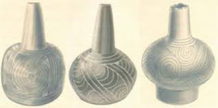
Fig. 6.6. For a thousand years Caddo women made the finest pottery east of the Rockies.
A GIANT RACE: THE INDIAN MOUND CHICKASAWBA
HUMAN SKELETONS EIGHT AND TEN FEET IN HEIGHT—RELICS OF A FORMER
RACE.
EVENING TELEGRAPH, SEPTEMBER 15, 1870
Two miles west of Barfield Point, in Arkansas County, Ark., on the east bank of the lovely stream called
Pemiscot river, stands an Indian mound, some twenty-five feet high and about an acre in area at the top. . .
. The mound derives its name from Chickasawba, a chief of the Shawnee tribe, who lived, died, and was
buried there. This chief was one of the last race of hunters who lived in that beautiful region and who
once peopled it quite thickly . . .
Aunt Kitty Williams, who now resides there, relates that Chickasawba would frequently bring in for
sale as much as twenty gallons of pure honey in deerskins bags slung to his back. He was always a friend
to the whites, a man of gigantic stature and herculean strength. . . . He was buried at the foot of the mound
on which he had lived, by his tribe, most of whom departed for the Nation immediately after performing
his funeral rites. . . .
Chickasawba was perfectly honest and the best informed chief of his tribe. . . . A number of years ago,
making an excavation into or near the foot of Chickasawba’s mound, a portion of a GIGANTIC HUMAN
SKELETON was found. The men who were digging, becoming interested, unearthed the entire skeleton
and from measurements given us by reliable parties the frame of the man to whom it belonged could not
have been less than eight or nine feet in height. Under the skull, which slipped easily over the head of our
informant (who, we will here state, is one of our best citizens), was found a peculiarly shaped earthen jar,
resembling nothing in the way of Indian pottery, which has before been seen by them. It was exactly the
shape of the round-bodied, long necked carafes or water-decanters, a specimen of which may be seen on
Gaston’s dining table.
The material of which the vase was made was a peculiar kind of clay and the workmanship was very
fine. The belly or body of it was ornamented with figures or hieroglyphs consisting of a correct
delineation of human hands, parallel to each other, open, palms outward, and running up and down the
vase, the wrists to the base and the fingers toward the neck. . . . Since that time, wherever an excavation
has been made in the Chickasawba county in the neighborhood of the mound SIMILAR SKELETONS
have been found and under the skull of every one were found similar funeral vases, almost exactly like the
one described. There are now in this city several of the vases and portions of the huge skeletons.
One of the editors of the Appeal yesterday measured a thigh bone, which is fully three feet long. The
thigh and shin bones, together with the bones of the foot, stood up in a proper position in a physician’s
office in this city, measured five feet in height and show the body to which the leg belonged to have been
from nine to ten feet in height. At Beaufort’s Landing, near Barfield, in digging a deep ditch, a skeleton
was dug up: the leg of which measured between five and six feet in length, and other bones in proportion.
In a very few days we hope to be able to lay before our readers accurate measurement and descriptions of
the portions of skeletons now in the city and of the artifacts found in the graves. It is not a matter of doubt
that these are HUMAN REMAINS, but of a long extinct race.

The following article on archaeological finds made in Oklahoma while digging for a new dam opens with
an unexpectedly apologetic headline.
DAM DESTROYS EVIDENCE FOR CITY OF 100,000
RAY E. COLTON, SCIENCE WRITER DAILY NEWS-RECORD, MIAMI, OKLAHOMA, DECEMBER 4, 1939
While construction of the Grand River Dam in Mayes County will be of vast value to the residents of this
area and others, it has already proven a “boon” to archaeological research insofar as finds made in the
form of skeleton remains of prehistoric man during excavation work are concerned. During the last week
two large burials have been unearthed, one of which contained several dozen decapitated skulls, showing
that the early day races of eastern Oklahoma tribes did away with their enemies in a unique manner.
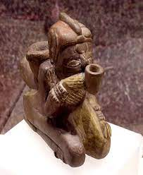
Fig. 6.8. The Great Mortuary: effigy of a man smoking a pipe made of Missouri flint clay (courtesy of Herb Roe).

Fig. 6.9. Engraved whelk shell cup with raptor head (courtesy of Herb Roe)

Fig. 6.10. Craig Mound—also called the Spiro Mound—is the second-largest mound on the site and the only burial mound. It
is located about 1,500 feet (460 meters) southeast of the plaza (courtesy of Herb Roe).
A cavity created within the mound, about 10 feet (3 m) high and 15 feet (4.6 m) wide, allowed for
almost perfect preservation of fragile artifacts made of wood, conch shell, and copper. The conditions in
this hollow space were so favorable that objects made of perishable materials such as basketry, woven
fabric of vegetal and animal fibers, lace, fur, and feathers were preserved inside it. Such objects have
traditionally been created by women in historic tribes. Also found inside were several examples of
Mississippian stone statuary made from Missouri flint clay and Mill Creek chert bifaces, all thought to
have originally come from the Cahokia site in Illinois.

Fig. 6.11. Copper ear spool (courtesy of Herb Roe)
A DOZEN "ODD" SKULLS: SEVERAL DOZEN SKELETONS
Centuries before the arrival of white pioneers in what is today the geographical confines of Ottawa,
Mayes, and adjoining counties, a strange race, now known to archaeologists as the mound builders, came
to establish their governmental seats here.
This was definitely established only a few days ago in the discovery by workmen excavating for the
Grand River Dam, near Langley in Mayes County, of two large burials containing several dozen skeletons
and a dozen “odd” skulls, ranging from children to adults. An examination of these remains, which appear
to be in a fairly excellent state of preservation, by anthropologists from the University of Oklahoma, who
are now on the scene, shows that the skeleton remains are unmistakably those of a race of people known
as the mound builders.
MOUND BUILDER CAPITAL
The remains of mounds, such as effigy, burial, ceremonial, fortification etc., which have been found
throughout northern Mayes and eastern Ottawa counties, and which appear to centralize in this area
around Langley, near the Grand River Dam site, give ample proof that this section of eastern Oklahoma
evidently was the capital of this vanished race. . . .
SOMETHING TO THINK ABOUT
Large quantities of arrow-heads, ranging in size from the slender fish-point types, used to hunt small game
such as birds, up to the large war-points, ranging up to 10 inches in length have been found during
excavation work on the dam. These, together with quantities of pottery and potsherds (potions of pottery)
of many designs, which have been found, have given scientists and laymen something to think about as
regards the races that inhabited this part of eastern Oklahoma, centuries before the arrival of the white
man.
ARCHAEOLOGISTS SHOW PROOF FOR CITY OF 100,000
Tracing the area as it one-time appeared, and basing theories on the tremendous amount of artifacts found
by workmen during digging operations, it is established by anthropologists and archaeologists who are
now on the scene, that the “city,” if that is what it might have been called, had an area of about 10 square
miles, and no doubt supported an estimated population of over 100,000 people.
SEVENTY-FIVE COMPLETE SKELETONS
The remains of this vanished race consist of about 75 complete skeletons. Two distinct burials were
unearthed, one containing dozens of decapitated bodies, while the other contained an equal amount of
complete skeletons, which do not appear to have been mutilated.
The skeleton remains do not crumble when exposed to outside air, and appear to have been buried over
one thousand years, or more. An estimate of 1,500 years has been given by those who are excavating the
remains, part of which will be transferred to the University of Oklahoma at Norman for study and
classification.
HEADLESS BURIALS BAFFLE ANTHROPOLOGISTS
This find baffles archaeologists and anthropologists from the University of Oklahoma somewhat, yet it is
believed that the mound containing the headless burials is a sacrificial mound, where enemies were
buried after their capture during warfare.
The second burial is that of an ordinary burial mound, such as was unearthed near Grove in Delaware
County two years ago. Both burials are unmistakably those of mound-builder origin, and are certainly not
of Indian origin.
CLIFF DWELLERS
Although the cliff dwellers are generally thought of as a recent tribe, Smithsonian field reports from 1910
on a Puye cliff-dweller excavation describe signs of construction dating back at least five thousand years
at some of the kivas that they explored. In a report, Smithsonian correspondent M. J. Brown writes, “It is
estimated by the Smithsonian people that 10,000 lived on the face of this one cliff, and that the population
of the adjoining cliffs and on the mesas was fully 100,000 people.” Brown also comments on the great
quantities of Portland cement that were plastered in almost every one of the hundreds of rooms in the
settlement.
STAIRWAY TO HEAVEN
Most wonderful of all is the stairway that leads to the top of the cliffs. Here one gets some idea of the
ages that these people lived in this spot and the multitude who used this path, for human feet have worn
the solid rock to a depth of twelve inches, and when you consider that this outside rock is not of the soft
composition of the caves, then you have some conception of the age and the density of the population.
To give a further idea of just how distorted our view of the extent and size of the cliff dweller
population is, here is a report from the Oakland Tribune of 1926 about the discovery of a six-mile-long
city in Nevada.
ARIZONA GIANTS
EL PASO HERALD, APRIL 19, 1915
“The skeleton of a giant fully eight feet tall has been found near Silver City,” said H. E. Davis. The thigh
bone of this ancient inhabitant of the southwest measures two inches more than the ordinary man and must
have been a giant of great strength. The jaw bone is large enough to fit over the jaw of an ordinary man. A
peculiarity of the forehead is that it recedes from the eyes like that of an ape. The similarity is still further
found in the sharp bones under the eyes. The skeleton was found encased in baked mud, indicating that
encasing the corpse in mud and baking it was the mode of embalming. Near the skeleton was found a stone
weighing 12 pounds, which, judging from its shape, must have been a club. The wooden handle has rotted
away but there are marks on the stone that indicate that it had been bound to a wooden handle with tongs.
It is rather peculiar that less than 30 miles from where this skeleton was found and located on the Gile
river are the former houses of a tribe of small cliff dwellers. The existence of these two races so near
together forms an interesting topic. “These ‘gorilla like’ or ‘monkey-like’ skulls have been reported in
many states several times by Smithsonian personnel. Professor Thomas Wilson, the curator of Prehistoric
Anthropology for the Smithsonian, said the following about the find of an eight-foot-one-inch giant
skeleton in Miamisburg, Ohio, in 1897. “The authenticity of the skull is beyond doubt. Its antiquity is
unquestionably great. To my own personal knowledge several such crania were discovered in the
Hopewell group of mounds in Ohio, exhibiting monkey-like traits.”
IN NEVADA, A SIX-MILE-LONG STRAIGHT CITY
OAKLAND TRIBUNE, JANUARY 3, 1926
Out in Nevada Governor James Graves Scrugham and archaeologist M. C. Harrington announced the
discovery of Pueblo cities that pre-date the birth of Christ. The discoveries gained national attention a
year ago when Harrington first told of the finds.
“The ruins,” Harrington said, “run in a continuous line of six miles and are about a half mile wide. The
outlines of the houses of stone and adobe and the stone pavement are clearly seen.” Everywhere were
myriads of pieces of broken pottery. Later Harrington found evidence convincing him that the city had
existed 2000 years and was occupied for at least 1000 years. Then followed discoveries of tombs
decorated with turquoises and pearl shells cut into small beads. “These ancient Nevadans,” said Mr.
Harrington, “probably were the ancestors of our modern Pueblo tribes. . . .”
ANCIENT HIEROGLYPHS FOUND
In New Mexico and Arizona have been found communal dwellings from three to five stories high, in
which may have lived as many as 1200 Indians. They are believed to be between 2000 and 5000 years
old. Wide interest was aroused among scientists by the reports that certain hieroglyphs found on the walls
resemble those of the Chinese.
NO TRADITION OF CLIFF DWELLERS
BY M. J. BROWN
FIELD REPORT ON THE SMITHSONIAN’S
1910 PUYE CLIFF DWELLER EXCAVATION
“The Pueblos have no traditions, legends, or anything regarding these cliff people.”
SMITHSONIAN
REPRESENTATIVE, 1910
It is estimated by the Smithsonian people that 10,000 people lived on the face of this one cliff, and that the
population of the adjoining cliffs and on the mesas was fully 100,000 people.
SMITHSONIAN EXCAVATES 250
SKELETONS OF THE CLIFF DWELLERS
And just beyond this ruin is a burial ground where during the past summer, the Smithsonian people
excavated 250 skeletons and all kinds of trinkets and pottery buried with them. The graveyard is but
partially excavated and hundreds of other skeletons yet sleep there. From one of the caves in the cliff, Mr.
Hoag showed me some leg bones.
EXPLORING THE KIVA
About in the center of this long cliff is a stone stairway with a kiva at the foot. And I must tell you of the
kiva before we go up. The best description of it would be of a well perhaps ten feet across and twenty
feet deep.
The roof has long since washed away, and the hole is partially filled up, but the Smithsonian people
have excavated it and placed therein a ladder. We descended and there found the only fireplace, or rather
the ruins of one, that is to be found in the whole city. The floor is cement, and in front of the fireplace are
two rows of holes in the floor, six on a side, and the walls are full of niches, each seeming to conform with similar places on the opposite side.
This kiva is supposed to have been the secret room where the religious and ceremonial rites of these
strange people were performed and a room where but few of the cliff dwellers feet ever trod.
THE PORTLAND CEMENT PUZZLE
Where the great quantities of cement came from that plastered almost every room of these hundreds is
another for the puzzle department to go to. Nothing has ever been found here of the sticky nature, yet these
aborigines must have had a Portland source from somewhere, for it was used in abundance.
In but one room of the hundreds, is there any color. But in one we found the interior painted red, faded
through the many generations, but plainly, red, and the picture of some unintelligible man or animal over
this door and had first been carved and then painted.
We climbed the cliff, putting our patent leathers in the deep, worn footpath, and our gloved hands in the
hand-holds, and gained the top. What a sight!
There in the bright sunshine lay the ruins of a great communal dwelling, one building that once
sheltered 1,200 people, a human beehive of the days before history. Ages ago this house fell into ruins,
but it has been carefully excavated and cleared away, and the first story and its walls now stand as they
did when built.
The great building reminds one of our modern stockyards—an enclosure cut up into little rooms—each
room about five by ten feet—and each communicating with the other by a door about three feet high by
eighteen inches wide—just one great beehive with no outdoor entrances.
From the quantity of ruins it is pretty thoroughly established that this building was at least three stories
high, one great enclosure around a court, and with one main entrance, or street, which is clearly defined.
In the center, or court, there are many handsome stone relics, grinding stones, skinning stones, pieces of
pottery, and many whose use we can only guess at, but plainly fashioned for some purpose.
CARVING OF A HEART IS FOUND
Over the doors of many of the homes on the cliff’s face, are rock pictures—whose meaning I would give
much to read—and of some I am sure there are meanings. The sun symbol is prominent, and they were in
no doubt sun worshippers, while there are many crude drawings representing men, beasts, and birds. One
carving particularly interested me, as representing a heart.
ANCIENT CLIFF DWELLERS HAD DIFFERENT
SKULLS THAN THE
INDIANS
“There is too great a difference in the heads of the Cliff Dwellers skeletons and the present Indians to
allow any connection or relationship,” stated Hewitt of the Smithsonian expedition. “The Pueblos have no
traditions, legends, or anything regarding these cliff people. Old mountaineers will tell you that a plague
exterminated them; others that volcanic fumes stifled them at one stifle; and so on, but as stated, there is
absolutely nothing to bear out any change, but that of a slow order of extermination.”
NEW MEXICO DISCOVERY: 12-FOOT GIANT FOUND
NEW YORK TIMES, FEBRUARY 11, 1902
Owing to the discovery of the remains of a race of giants in Guadalupe, New Mexico, antiquarians and
archaeologists are preparing an expedition further to explore that region. This determination is based on
the excitement that exists among the people of a scope of country near Mesa Rica, about 200 miles
southeast of Las Vegas, where an old burial ground has been discovered that has yielded skeletons of
enormous size. Luciana Quintana, on whose ranch the ancient burial plot is located, discovered two
stones that bore curious inscriptions and beneath these were found in shallow excavations the bones of a
frame that could not have been less than 12 feet in length. The men who opened the grave say the forearm was 4 feet long and that in a well-preserved jaw the lower teeth ranged from the size of a hickory nut to
that of the largest walnut in size. The chest of the being is reported as having a circumference of seven
feet. Quintana, who has uncovered many other burial places, expresses the opinion that perhaps thousands
of skeletons of a race of giants long extinct, will be found. This supposition is based on the traditions
handed down from the early Spanish invasion that have detailed knowledge of the existence of a race of
giants that inhabited the plains of what now is Eastern New Mexico. Indian legends and carvings also in
the same section indicate the existence of such a race.
next
A COPPER KINGDOM AND MICA MINES
FAIR USE NOTICE
This site contains copyrighted material the use of which has not always been specifically authorized by the copyright owner. As a journalist, I am making such material available in my efforts to advance understanding of artistic, cultural, historic, religious and political issues. I believe this constitutes a 'fair use' of any such copyrighted material as provided for in section 107 of the US Copyright Law.
In accordance with Title 17 U.S.C. Section 107, the material on this site is distributed without profit to those who have expressed a prior interest in receiving the included information for research and educational purposes. Copyrighted material can be removed on the request of the owner.


No comments:
Post a Comment